ኣዱሊስ/Adulis/Ἄδουλις - Part 1: The Rise Of Adulis (300BC-200AD)
In this article, I will explore the early history of Adulis, covering the period from approximately 300 BC to 200 AD. During this era, Adulis thrived as a prominent city-state, in the Erythraean Sea.
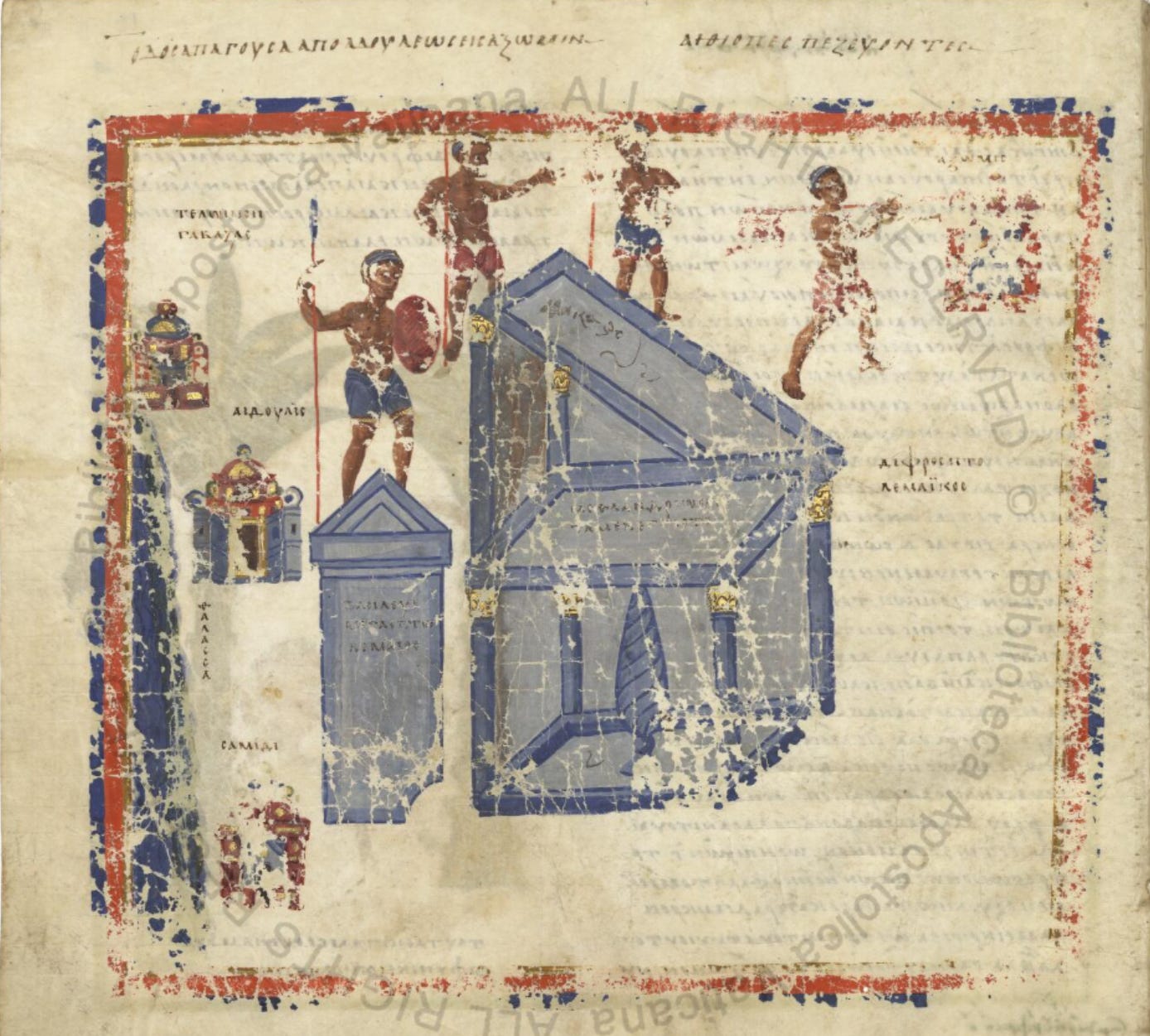
This map displays Adulis with an inverted orientation where the north is at the bottom and the south is at the top. In the bottom left corner, you'll find Samidi, above that is Adulis, with the harbour Gabaza situated at the very top. Towards the top right corner is Aksum. The text at the top left indicates the "Road leading from Adulis to Axum," while the top right text features says "Ethiopians on foot." (Source- Manuscript - Vat.gr.699, Vatican archives, 15v)
δουλ (doul) → from δοῦλος (doûlos), meaning “slave” (masculine)
-ις (-is) → a common noun suffix in Greek
Altogether, Ἄδουλις has been interpreted by some scholars as meaning “place without slaves.” However, this is one of several proposed etymologies and remains debated among historians and linguists1.
Adulis (Saho: ado lay) can be broken down as follows:
ado → ‘white’
lay → ‘water’
Referring to clear water, this term is used by the Saho people to describe various settlements known for having access to clean water sources2.
Adoulîtai (Greek: Ἀδουλῖται) breaks down as follows:
Ἀδουλ- → root from Ἄδουλις (Adulis)
-ῖται (-îtai) → a plural suffix denoting, people of a place
Altogether, Ἀδουλῖται means “the people of Adulis”
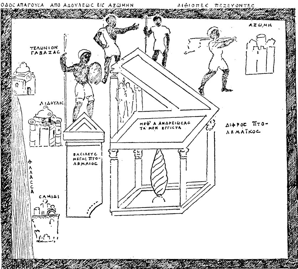
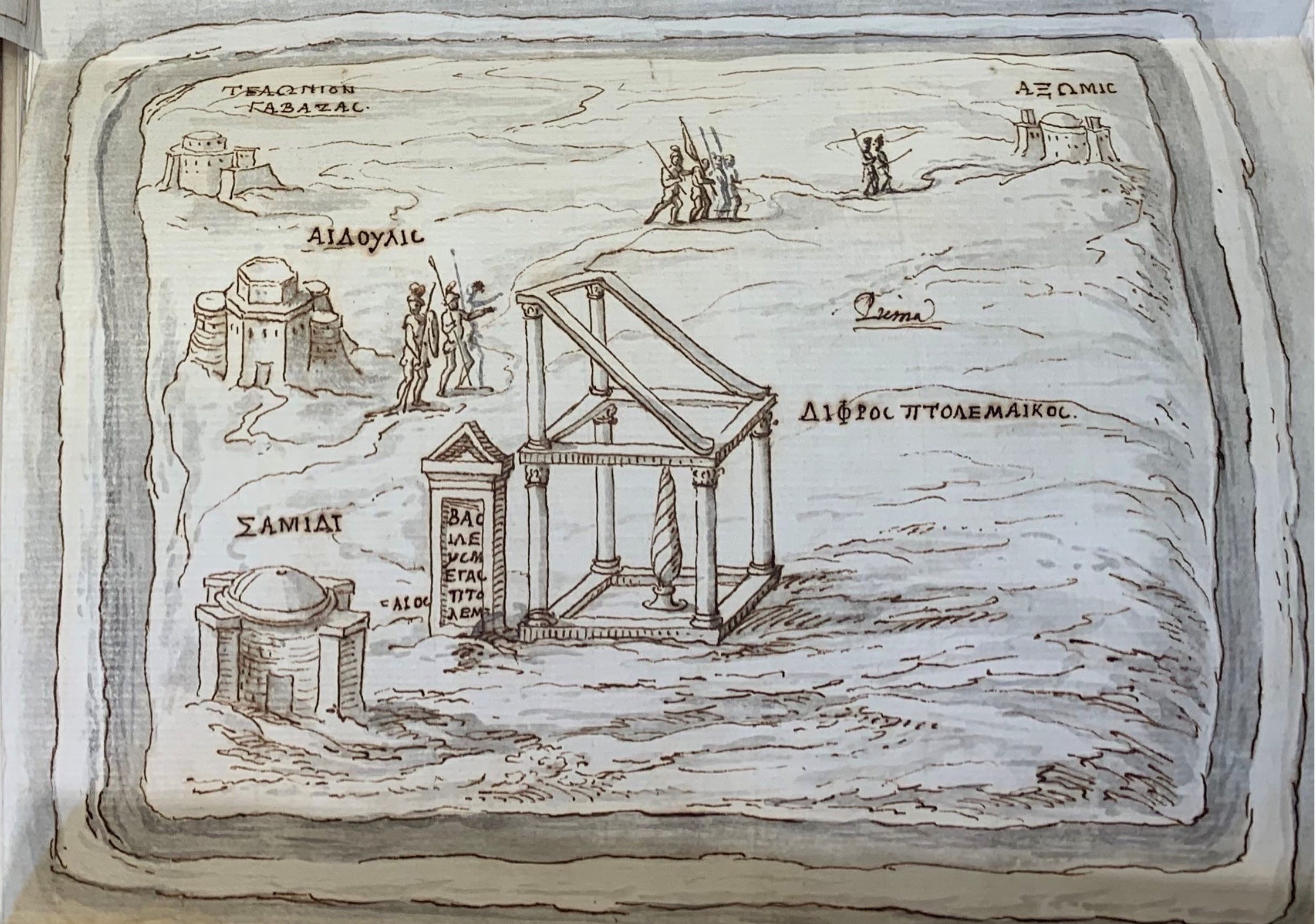
Map of Adulis By The 16th-century scholar Leone Allacci. Source: ‘One of the Most Curious Monuments of Antiquity’. Leone Allacci and the Monumentum Adulitanum, pg 156.
Adulis was one of the most important trading cities on the Erythraean Sea during antiquity. Merchants and travellers from as far as Rome, India & China visited the shores of the Gulf of Zula, where Adulis’s port, Gabaza, was situated. At one point, during the reign of Emperor ካሌብ (Kaleb) in the early 6th century AD, the port hosted a fleet of over 60 ships and tens of thousands of soldiers, serving as the launch point for Kaleb’s military expedition into Himyar. Around the same time, Adulite merchants were recorded by Cosmas Indicopleustes as crossing the Bab al-Mandeb and traversing the Persian Gulf, reaching as far as Sri Lanka3. Mercentile activities were just one domain, as Adulite priests were recorded travelling to the courts of Constantinople to participate in the vibrant theological councils and religious debates of the 5th century4.
A contentious topic of discussion is whether Adulis was merely a port city under Aksumite rule or an entirely independent entity.The reality lies somewhere in between. As we will soon explore, Adulis predates the rise of the Aksumite Empire as it existed in some form as far back as the Puntite era. Therefore, it cannot be described as just an Aksumite port. However, during the later phases of Adulis’s history (particularly between the 3rd and 6th centuries AD), it was, at least during certain periods, incorporated into Aksumite control. This is evident in the writings of travellers such as Cosmas Indicopleustes in the 6th century AD, who refer to it in as an Aksumite port . Still, even during this period, Greek sources often distinguish between Adulites and Aksumites, suggesting that full integration was never entirely realised. That said, this article focuses on the period prior to the 2nd century AD, before the emergence of the Aksumite Empire, so a deeper discussion of Adulis’s later relationship with Aksum will be reserved for a subsequent article.
Nevertheless, the history of Adulis extends far further back than the 4th and 5th centuries AD. Recent archaeological evidence, including obsidian samples5 and genetic tracing from baboons6, links Adulis to the ancient Land of Punt (as discussed in greater detail in my article on the Land Of Punt), this suggests that Adulis may have been one of its key ports, thereby potentially dating the port cities origins as far back as the 2nd to 3rd millennium BC.
Carved alabaster slabs, possibly parts of a stone throne from Adulis, dated to the mid-1st Millennium BC. Source: Adulis Before Aksum, Figure 5.
Unfortunately, little is known about the period following the Land of Punt (~1000 BC onwards) up to the Ptolemaic Era of Egypt (~4th–3rd century BC). This gap is largely due to the limited archaeological research conducted at Adulis. However, other reasons for the lack of information might include the decline in trade with Egypt (and by extension, with other Mediterranean civilisations) during the mid to late first millennium BC. This downturn coincided with the weakening of the Egyptian state during the Third Intermediate Period, as discussed in my section The Fall of DʿMT in the DʿMT article. Trade would later be revived throughout the Erythraean Sea during the reign of the Ptolemaic dynasty, beginning around the 4th century BC.
Archaeological work at Adulis is ongoing, and just last year, new evidence of settlement, such as ceramics and other pottery dating from 1500 BC to 100 BC was uncovered7. These findings may offer valuable look into this little-known era of Adulis's early history.
This article focuses on the earlier history of Adulis, specifically from around 300 BC to 200 AD, a period of around half a millennium. To reconstruct this period, I will draw upon both primary and secondary sources. Many of the primary accounts come from contemporary Greek writers, who referred to the inhabitants as Adoulîtai /Adulites and the city as Adule or Adulis. As we will see, cultural ties with the Greek world were particularly strong during this time. Given that Adulis was a merchant city during an era when Greek served as the lingua franca of regional trade, this is hardly surprising.
In addition, primary inscriptions and artefacts discovered at Adulis itself will also be examined to give a better understanding of what occurred during this period.
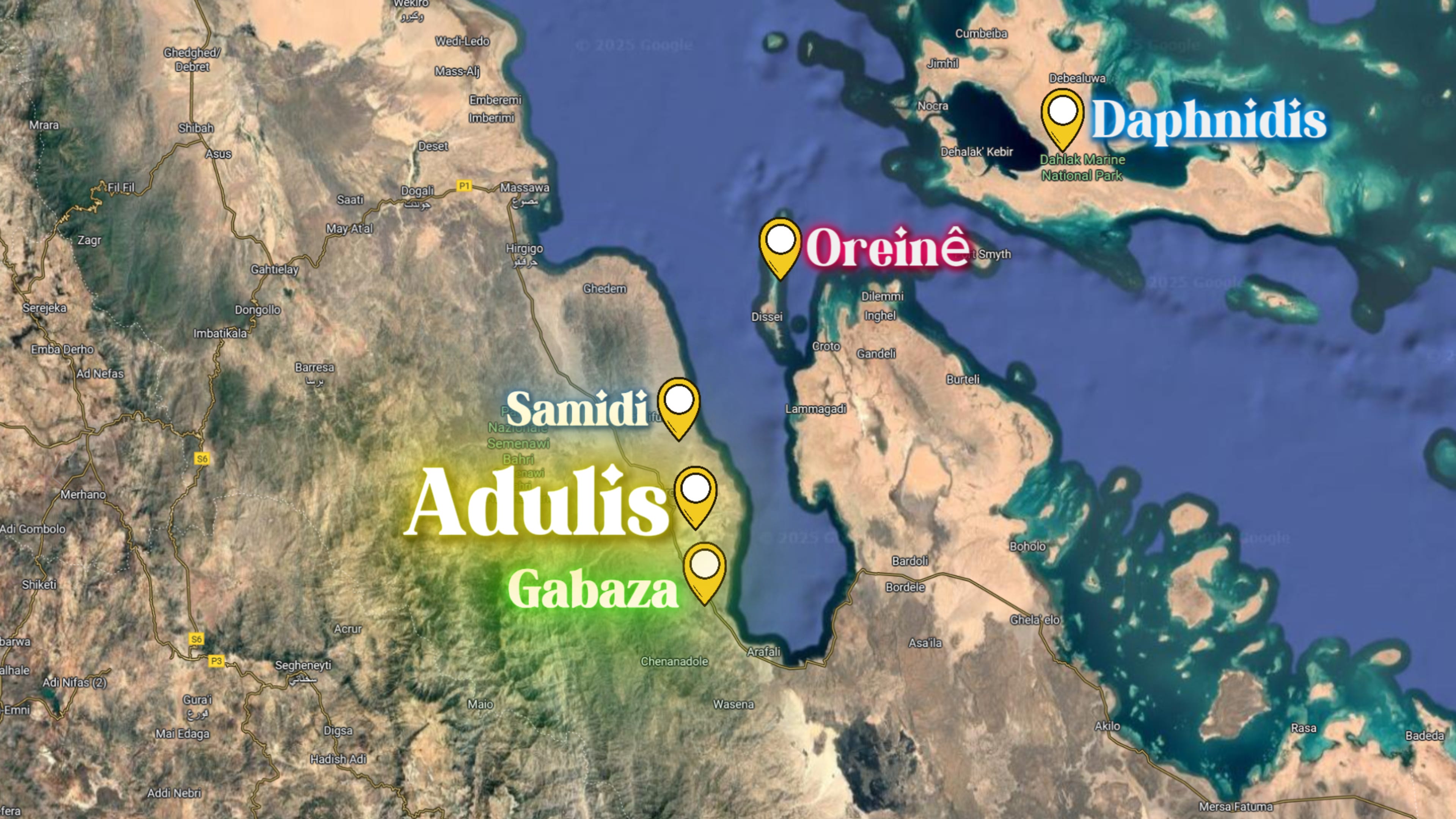
Location Of Adulis
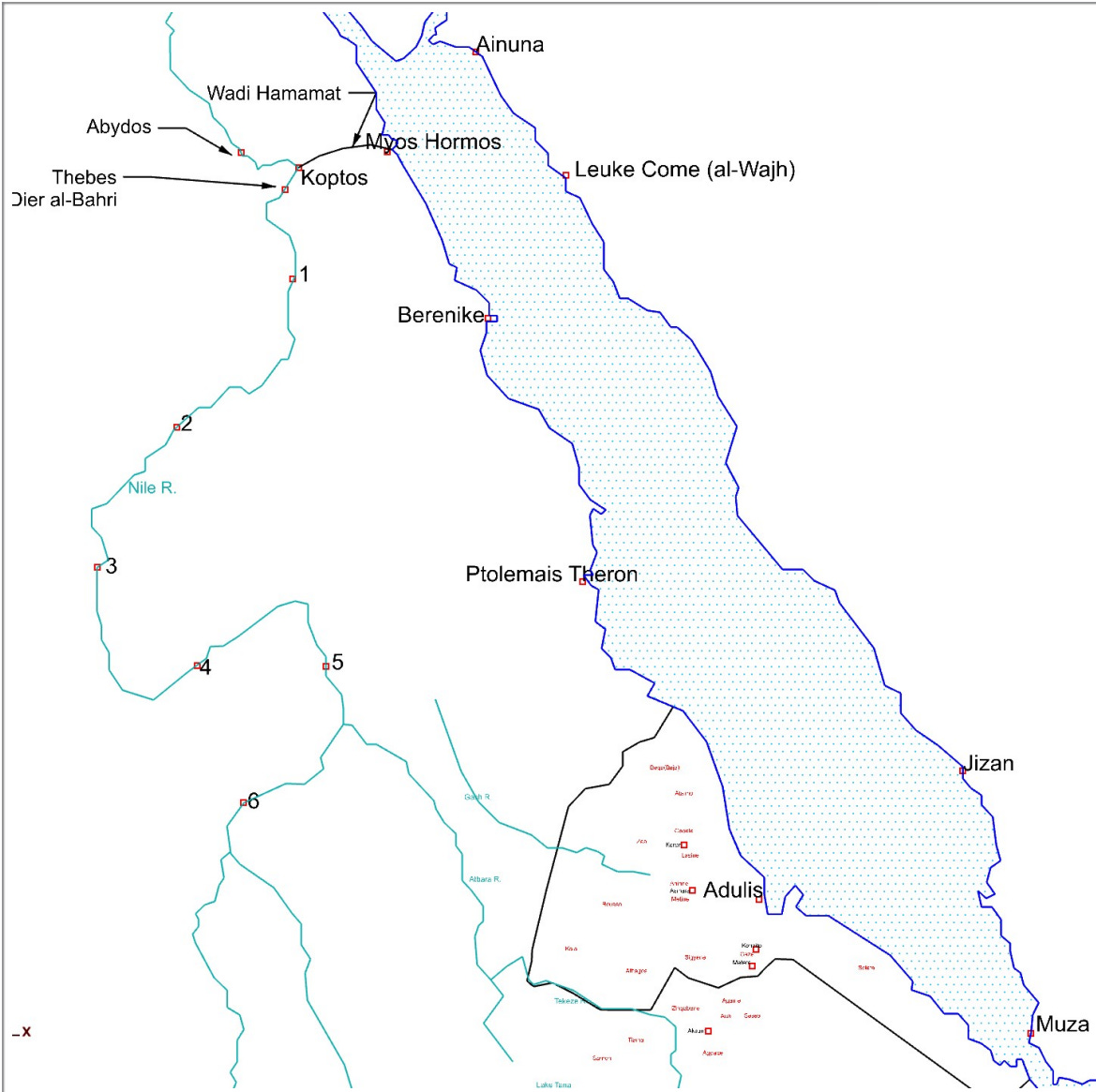
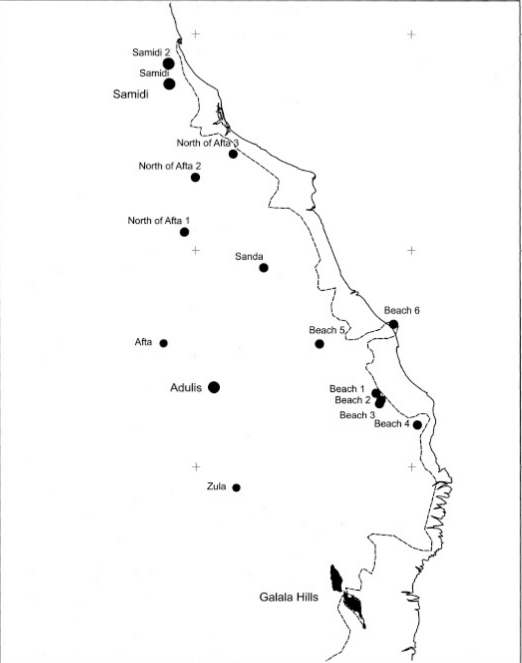
Rough map of Adulis and known locations during antiquity, based on The Ancient Red Sea Port of Adulis, Eritrea: Results of the Eritro-British Expedition, 2004–5, Figure 5.2.
Adulis, now located over 5 kilometres from the Gulf of Zula, was theorised to have been much closer to the sea in ancient times, approximately 3.3 kilometres in fact8. Due to siltation, this ancient city now lies much further away from the coast. Adulis is situated next to three rivers, with the northernmost one being the Haddas River, on which Adulis is located. Merchants used the Haddas River to help guide them on their travels southwards to the town of Qohaito and further south all the way to Aksum and beyond….9.
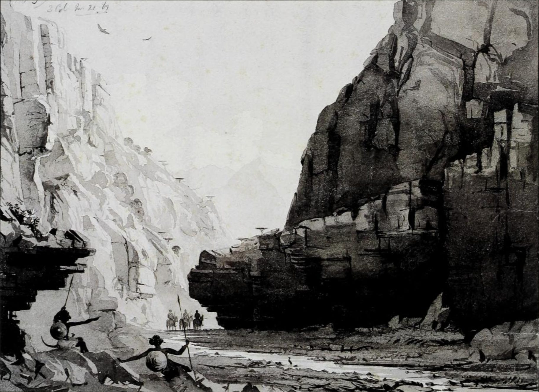
Painting showing the Sahos near Zula during the British Expedition to Abyssinia. Source: Abyssinia, 1867-1868: Artists on Campaign — Watercolors and Drawings from the British Expedition under Sir Robert Napier, p. 38.
Thanks for reading HYohannes! Subscribe for free to receive new posts and support my work.
The port of Gabaza
While Adulis served as the bustling port city where merchants conducted trade and local rulers resided, the actual harbour where ships moored was likely at a site called Gabaza, as mentioned in the text Martyrs of Najran, which describes the 6th-century AD military conquest of the Himyarite kingdom by Emperor Kaleb of Aksum.
It reads as follows:
“…By the providence of the Saviour 60 merchant ships of Romans. Persians and Ethiopians, as well as from the islands of Pharsan,70 were also assembled; 15 ships from the city of Aela; 20 from Klysma;71 seven from Iotabe;72 two from Berenice;73 seven from Pharsan; and nine from India. Elesbaan gathered them together into one naval station called Gabazan, within the borders of Adulis” - Martyrs of Najranm pg 21.
Archaeologists have recently proposed that Gabaza was located in the Galala Hills, south of Adulis, where the ruins of two ancient circular watchtowers and pottery resembling the region’s antiquity style have been discovered10.
Architectural ruins at Samidi. Source: The Throne of Adulis: Red Sea Wars on the Eve of Islam, Figure 7.5.
Gabaza was also mentioned in an Aksumite inscription (DAE 811) , scholars suggest this is possibly in reference to a King of the port town12.
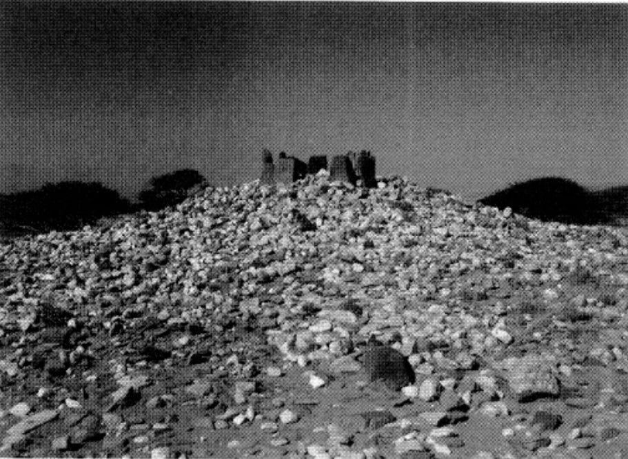
Samidi
Samidi, a town mentioned on Cosmas Indicopleustes’ map, may correspond to a site located 7 km north of Adulis. Several ancient architectural fragments have been discovered there, along with a mound containing the ruins of what may have been a large building measuring 40 metres in length and 25 metres in width13.
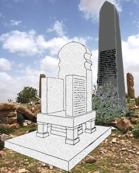
The Great Stele of Adulis (~241- 221 BC)
Reconstruction of the Throne of Adulis and the Basilt Stele. (Own Work + Adaptation Of Ältere denkmäler Nordabessiniens, pg 66)
Two of the most significant monuments once found at Adulis—now lost to history—were the Basilic Stele of Adulis and the Marble Throne. Each commemorated the conquests of different rulers from different eras: the stele recorded the campaigns of Ptolemy III, while the throne belonged to an unnamed indigenous ruler from the Common Era onwards. Both held immense importance for the Adulite people. As noted by Cosmas Indicopleustes, criminals were even executed in front of the throne & Emperor Kaleb made it a priority to copy these inscriptions before heading out for his expedition (It’s no doubt important to learn the conquests of others before attempting one yourself).
Therefore, to understand the earliest part of Adulis’ history, it’s important to understand the contents of this Basilt Stele.
The Structure Of The Stele
When the 6th century Explorer/Merchant Cosmas Indicopleustes ventured to Adulis at around 522 to 523 AD 14 , he came as part of a group of merchants15 sent forth from Alexandria in Egypt, when he landed at Adulis he remarked at the marble throne that he had observed, this throne had inscriptions written on the sides, in addition to the throne lay a stele made of basalt. Cosmas notes that the Emperor ካሌብ/Kaleb (Greek: Ἐλεσβαὰν → Elesbaan) had asked the Ruler (ἄρχων→ắrkhōn) of Adulis (whose name is ᾿Ασβᾶς/Asbas/Abbas) to have a copy of the inscriptions written down and sent to him. Abbas then assigned this task to Cosmas and his fellow Merchant Menas, knowing both were proficient in Greek and could thus decipher the Greek written on the stele & throne.
Luckily for us, Cosmas and Menas copied the inscription more than once, with one copy being given to Abbas, while the other was kept for themselves.
The following excerpt regarding the throne and stele is taken from Cosmas Indicopleustes:
“On the coast of Ethiopia, two miles off from the shore, is a town called Adule, which forms the port of the Axomites and is much frequented by traders who come from Alexandria and Eilat. Here is to be seen a marble chair, just as you enter the town on the western side by the road which leads to Axomis. This chair appertained to one of the Ptolemies, who had subjected this country to his authority. It is made of costly white marble such as we employ for marble tables, but not of the sort which comes from Proconnesus. Its base is quadrangular, and it rests at the four corners on four slender and elegant pillars, with one in the middle of greater girth and grooved in spiral form. The pillars support the seat of the chair as well as its back against which one leans, and there are also sides to right and left. The whole chair with its base, five pillars, seat and back and sides to right and left, has been sculptured from a single block into this form. It measures about two cubits and a half, and is in shape like the chair we call the Bishop's throne. Behind the Chair is another marble of basanite stone, three cubits in height and of quadrangular form, like a tablet, which at the centre of its upper portion rises to a sharp point whence the sides slope gently down in the form of the letter lambda (λ), but the main body of the slab is rectangular. This tablet has now fallen down behind the Chair, and the lower part has been broken and destroyed. Both the marble and the chair itself arc covered over with Greek characters. Now when I was in this part of the country some five and twenty years ago, more or less, at the beginning of the reign of the Roman Emperor Justinus”- Cosmas Indicopleustes, Christian Topography (1897) pp. 23-90. Book 2, section 140
Cosmas mistakenly attributes both the Stele and the Throne as being created by the same person and at the same time. However, in reality, scholars believe the Stele was likely erected much earlier than the Throne. The Stele describes the conquests of Ptolemy III, while the inscriptions on the Throne detail the conquests of an indigenous ruler of the land16.
It then continues…
“Elesbaan, who was then King of the Axomites, and was preparing to start on an expedition against the Homerites on the opposite side of the Gulf wrote to the Governor the Adule directing him to take copies of the inscriptions on the Chair of Ptolemy and on the tablet, and to send them to him. Then the Governor, whose name was Abbas, applied to myself and another merchant called Menas, who afterwards became a monk at Rhaithu, and not long ago departed this life — and at his request we went and copied the inscriptions. One set of the copies was made over to the Governor; but we kept also like copies for ourselves which I shall here embody in this work, since their contents contribute to our knowledge of the country, its inhabitants, and the distances of the several places. We found also sculptured on the back of the Chair figures of Hercules and Mercury; and my companion, Menas, of happy memory, alluding to these would have it that Hercules was the symbol of strength and Mercury of wealth. I remembered, however, the Acts of the Apostles, and would on this one point differ from him, upholding that we should take Hermes rather as the symbol of speech, for it is recorded in the Acts that they called Barnabas, Jupiter, and Paul, Mercury, because he was the chief speaker. Here is the form of the Chair and of the marble, and Ptolemy himself”. - Cosmas Indicopleustes, Christian Topography (1897) pp. 23-90. Book 2, section 141
Hercules was the Roman equivalent of the Greek legendary hero Heracles, the son of Zeus and the mortal woman Alcmene, while Mercury corresponded to the Greek god Hermes, the god of merchants. Could this allude to the importance of War & Trade by the inhabitants of Adulis?
Left: Statue Of Heracles. Right: Statue of Hermes
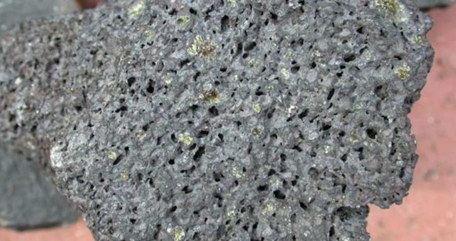
In both excerpts, we find information regarding the structural details of the Stele and the Throne. Focusing on the Stele, the Stele is said to be made of Basalt. Basalt is a common type of volcanic rock found in the Danakil Depression, south of Adulis, so it is plausible that these rocks were mined and used to construct the Stele17.
Vesicular Basalt, found around Adulis and commonly used in architecture found at Adulis. Source: Modelling the Local Political Economy Of Adulis pg 71
Secondly, rectangular steles have been discovered throughout the highlands of Eritrea and Ethiopia, dating back to the early and mid-first millennium BC. For example, several such steles have been found at Käskäse (as discussed in greater detail in my article on Early Antiquity Societies in Eritrea’s Akkälä Guzay region). This suggests that the stele in question was very likely crafted indigenously. We can also ascertain that the stele was around 1.5 meters in height (one ancient Greek cubit is around ~0.4-5 meters in height18).
From the above excerpts, we also understand that by the time Cosmas visited Adulis in the early 6th century, the stele had been broken, with its lower part destroyed. While the exact reason for this remains uncertain, it is highly unlikely that it was left unrepaired due to a lack of will. It is more plausible that the stele was deliberately broken and left in that state because it was disfavored by the local inhabitants of Adulis and the regional king, particularly due to the inscriptions on its lower part. However, we can’t be sure until more evidence is brought to light.
Cosmas as depicted in the Bibliotheca Augustana, courtesy of Ulrich Harsch. Source
So, what exactly was inscribed on this basalt stele, and when was it created? As we shall see, the stele records the military campaigns of Ptolemy III Euergetes, who reigned between 246 and 222 BCE. But this raises an intriguing question—why would a monument commemorating him be located thousands of kilometres away from Alexandria? Let’s find out…
The Ptolemaic Era(~305BC-30BC)
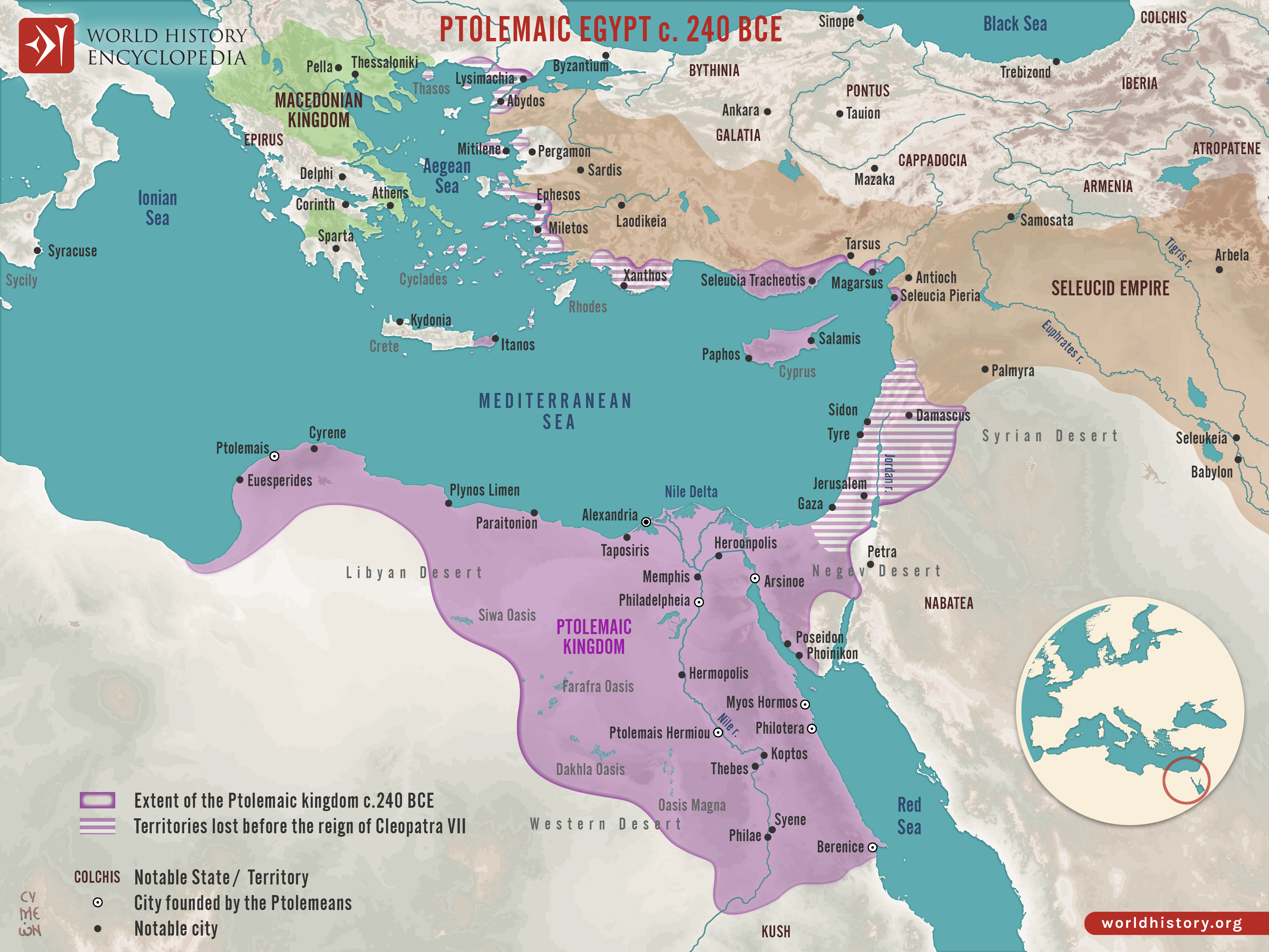
Map of Ptolemaic Egypt and its surrounding territories during the reign of Ptolemy III Euergetes, circa 240 BCE. Source
The Ptolemaic Dynasty was the last dynasty that ruled Egypt prior to its annexation by Rome. It was founded by Ptolemy I, a general of Alexander the Great and it lasted roughly 300 years (305BC to 30BC)19.
As previously discussed, the Ptolemaic dynasty ushered in a new era of trade in the Erythraean Sea, particularly during the reigns of Ptolemy II Philadelphus and Ptolemy III Euergetes. Ptolemy II established several coastal ports along the Erythraean Sea, including Philotera and Ptolemais Theron (“Ptolemais of the Hunts”)20, the latter named in honour of his fondness for hunting in the region.
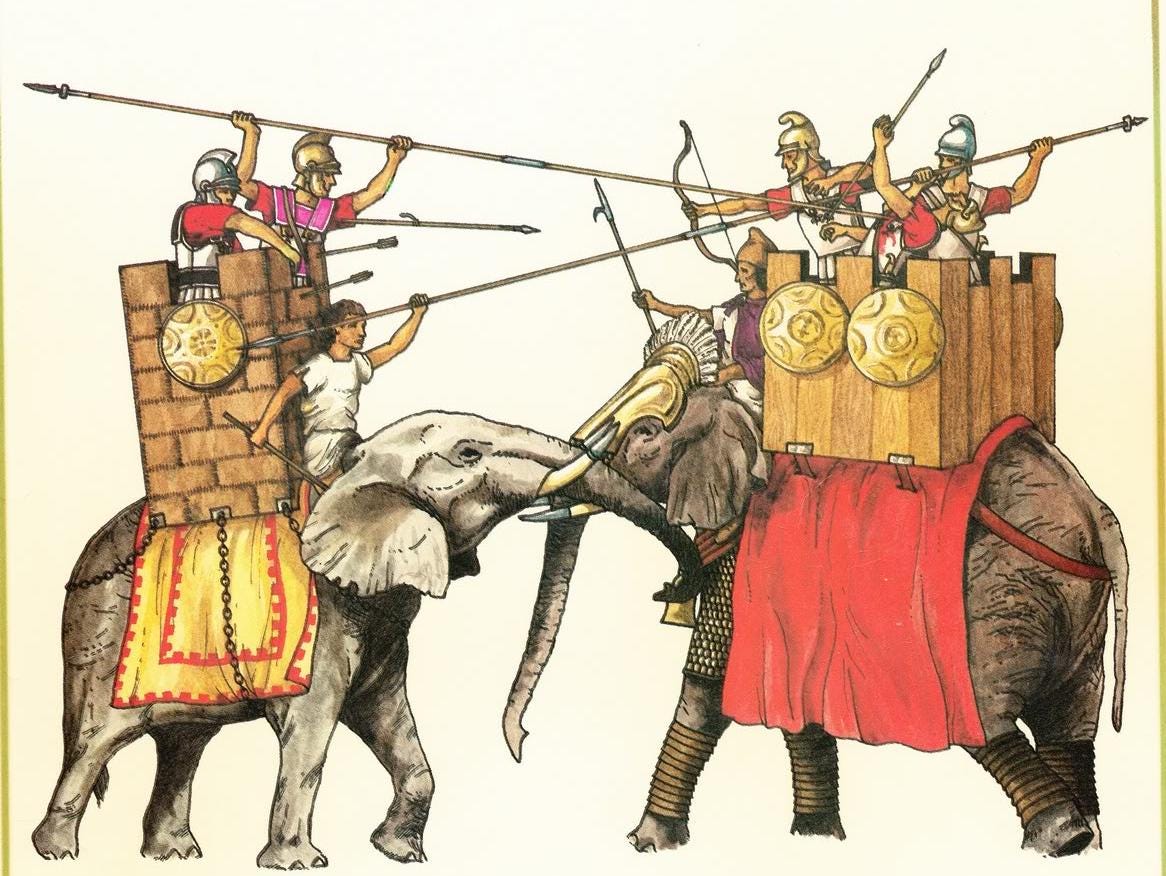
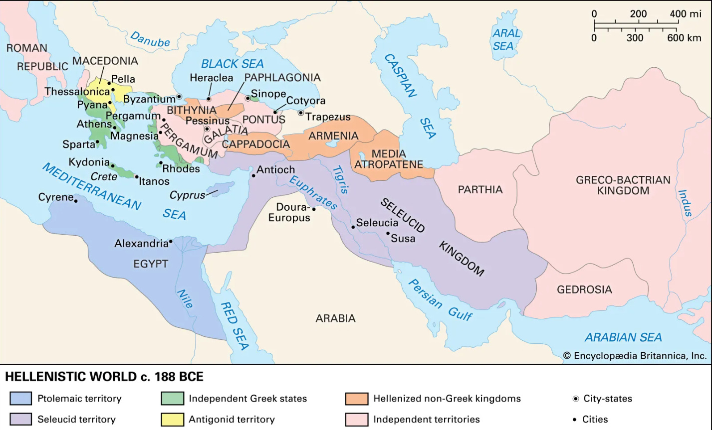
Ptolemy II’s passion for hunting was not merely recreational. Elephants played a crucial role in warfare (nicknamed the "Tanks” of antiquity), particularly in conflicts against their chief rivals, the Seleucids, who ruled over Persia, Mesopotamia, the Levant, and parts of Anatolia (modern-day Turkey). The seleucids restricted access to Indian elephants, thus it became an imperative for Ptolemy II to secure an alternative source. As we shall see, that source lay in the region surrounding Adulis…
It is not difficult to imagine that the expansion of trade and the increased maritime security provided by Ptolemaic Egypt contributed to Adulis’s revival following the economic downturn of the preceding era.
The extent of Ptolemy II power can’t be understated: “[Ptolemy] takes slices of Phoenicia and Arabia and Syria and Libya and the dark-skinned Ethiopians; all the Pamphylians and the warriors of Cilicia he commands, and the Lycians and the Carians, who delight in war, and the islands of the Cyclades, for his are the finest ships sailing the ocean.” - (Theocritus, lines 90-91)
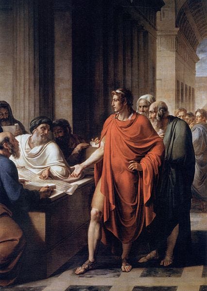
Ptolemy II Philadelphus Founds the Library of Alexandria. Source
The Inscription On The Stele
Ptolemy II’s son, Ptolemy III, would then utilise the newly captured elephants in his wars against the Seleucids. These wars are described in the Stele of Adulis as follows:
“The great king, Ptolemy, son of King Ptolemy and Queen Arsinoe, twin gods, grandson of the two sovereigns King Ptolemy and Queen Berenice — savior gods — sprung from Hercules the son of Jupiter on the father's side, and on the mother's side from Dionysus the son of Jupiter — having received from his father the Kingdom of Egypt and Libya and Syria and Phoenicia and Cyprus, and Lycia and Caria, and the Islands of the Cyclades, made an expedition into Asia with forces of infantry and cavalry, and a fleet and elephants from the Troglodytes and Ethiopia — animals which his father and himself were the first to capture by hunting in those countries, and which they took down to Egypt, where they had them trained for employment in war. And when he had made himself master of all the country on this side of the Euphrates, and of Cilicia and Pamphylia and Ionia, and the Hellespont and Thrace, and of all the forces in the provinces, and of the Indian elephants, and had also made subject to his authority all the monarchs who ruled in these parts,
he crossed the Euphrates river, and when he had subdued Mesopotamia and Babylonia and Susiana and Persis and Media, and all the rest of the country as far as Bactriana, and had collected all the spoils of the temples which had been taken away from Egypt by the Persians, he conveyed them to that country along with the other treasures, and sent back his troops by canals which had been dug.
Coinage bearing the image of Ptolemy III, with a reverse depicting a cornucopia—a horn filled with fresh fruits and nuts. Source
The conquests mentioned in the inscription refer to the Third Syrian War21, which was fought between the Ptolemaic Dynasty and the Seleucid Empire between 246 and 241 AD22. The conflict was sparked by a succession dispute following the death of Antiochos II. His wife Laodike claimed the throne for her son, Seleukos II, asserting that Antiochos II had named him heir at his deathbed. However, Berenice Syra (daughter of Ptolemy II, sister of Ptolemy III, and also wife of Antiochos II) contested this claim, insisting her own son was the rightful successor. She appealed to her brother Ptolemy III for support, but before action could be taken, both she and her son were assassinated. This event prompted Ptolemy III to declare war on the Seleucid Empire23.
Interestingly, he notes the use of war elephants captured from regions referred to as Troglodytes and Ethiopia, both fluid geographical toponyms in antiquity. During the time of Ptolemy III, "Troglodytes" generally denoted the area stretching from just north of Adulis to southern Egypt (around Berenice), primarily inhabited by the Beja people. "Ethiopia," on the other hand, referred to a broader region encompassing parts of present-day Sudan, Eritrea, and Ethiopia.
Troglodytes (Greek: τρωγλοδύτης24) breaks down as follows:
τρώγλη (trōglē) → “hole”
δύω (dúō) → “to enter” or “to dive into”
-της (-tēs) → a suffix indicating a person/people in this context.
Altogether, τρωγλοδύτης means “one who creeps into holes” or “cave-dweller”.
Aithíops (Greek: Αἰθίοψ25) breaks down as follows:
αἴθω (aíthō) – “to burn”
ὤψ (ṓps) – “face” or “appearance”
So Αἰθίοψ means “burnt-face”, a term used by ancient Greeks to describe people with a dark skin complextion, typically those living in the regions of present-day Sudan, Ethiopia, and Eritrea.
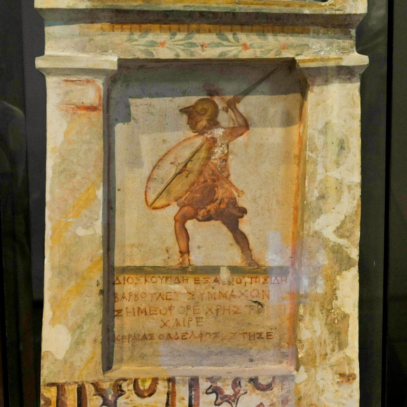
Funerary Stele of Dioscourides of Balboura, a Ptolemaic Soldier (Possibly a Mercenary). Source
Ptolemy III then claims to have employed these war elephants to capture territories across the Levant up to the Euphrates River in what is now modern-day Iraq. From there, he reportedly advanced northwards into Anatolia (present-day Türkiye). While many of these conquests are attested26, their extent is likely exaggerated.
He further proclaims to have crossed the Euphrates, subdued Mesopotamia, and pushed into Persia, claiming victories as far as Bactriana (a region encompassing parts of present-day Afghanistan, Tajikistan, Uzbekistan, and Turkmenistan). However, scholars question whether he ever held direct control over these distant regions, or even truly conquered them27. It is more plausible that the term “subdued,” as used in the inscription, implies forcing these territories into a state of peace (which did occur in 261 BC28).
The final section of the inscription notes that a small portion of the lower part of the inscription was fractured and presumably lost. As previously discussed, this may have been the result of deliberate defacement rather than environmental or accidental damage. One must wonder what was written there to provoke such an act. In many cases, the closing lines of monumental inscriptions are dedicatory, offering praise to the gods for the ruler’s triumphs.
Nevertheless, one thing is clear: war elephants played a crucial role in Ptolemy III's military campaigns. Since these elephants were sourced from the region around Adulis, it is unsurprising that a stele was commissioned and erected there, likely as an expression of gratitude and to enhance the ruler’s prestige in one of the farthest reaches of the known world at the time - Adulis.
Battle Of Raphia
Painting Depicting the Army of Ptolemy IV Philopator and Their Iconic War Elephants at the Battle of Raphia. Source
Scholars have also proposed that the African elephants used by Ptolemy IV, in the Battle of Raphia in 217 BC, were sourced from Adulis and its surrounding region29. According to the Greek historian Polybius, approximately 73 African war elephants participated in the battle.
However, scholars remain divided on whether these were savanna (larger) or forest (smaller) elephants. The ancient historian Polybius described the African elephants as smaller than Asian elephants, but the accuracy of this claim is hotly debated30. While Eritrea's modern elephant population consists of the larger savanna type, some scholars suggest that the ancient population may have differed from today’s.
Left: African forest elephant, Right: Asian Elephant. Source
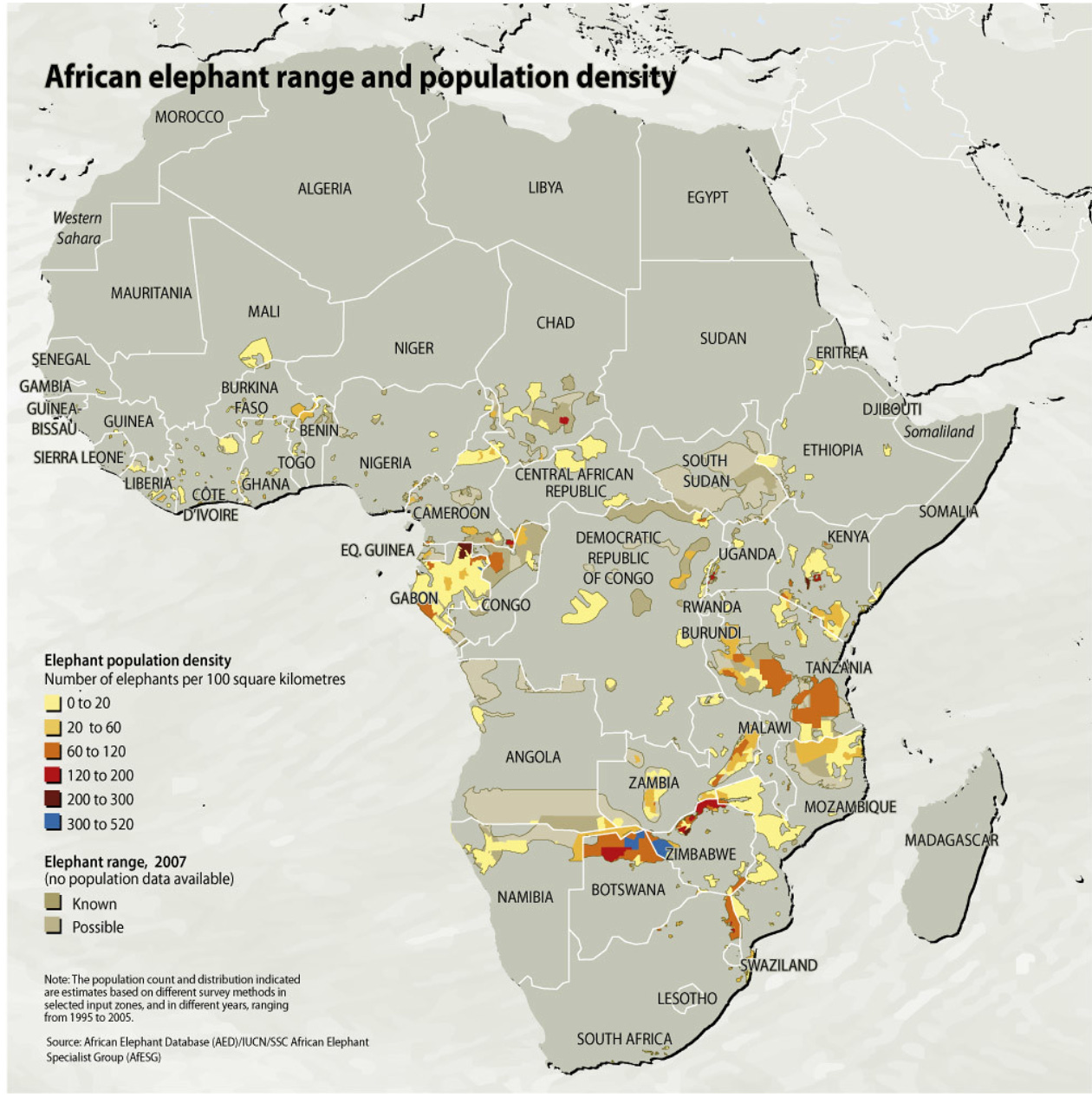
In modern times, Eritrea is home to one of the northernmost populations of Elephants in Africa31. Today, only around a hundred elephants remain in Eritrea, primarily confined to the Gash-Barka region. However, this was not always the case. In the 6th century, the Roman ambassador Photius, who travelled from the port of Adulis to Aksum, reported encountering a large herd of elephants roughly halfway along his journey (likely near present-day Matara).
“He tells us that Adulis is fifteen days' journey from Axumis. On his way there, he and his companions saw a remarkable sight in the neighbourhood of Aue (Ave), midway between Axumis and Adulis; this was a large number of elephants, nearly 5000. They were feeding in a large plain, and the inhabitants found it difficult to approach them or drive them from their pasture. This was what they saw on their journey.” - Photius, Bibliotheca excerpts, 3.5.
African elephant range and population distribution. Source
The use of elephants in warfare by the Ptolemies strongly implies that they were trained for combat beforehand. It is likely that this training occurred partly, if not entirely, in the region around Adulis before the elephants were exported to Egypt by merchants32.
The 100-cent coin in Eritrea shows an Elephant with its calf. Source
Elephants must be reared and trained from a young age, particularly for warfare. The process starts by fostering a relationship with older elephants; through interactions such as play-fighting, the younger elephants then come to recognise the trainer as part of the social hierarchy and form bonds accordingly33.
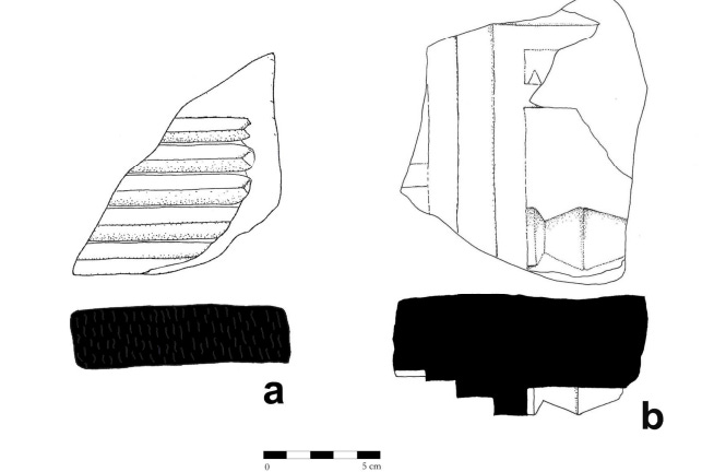
The mahout—the rider and handler of the elephant—relies on a specialised technique involving a metal rod used to tap the elephant’s ears. The location and intensity of these taps communicate different commands34. Notably, two bronze mahout rods have been discovered at Adulis, further supporting the idea that elephant training took place there.
Two Mahouts found at Adulis. Source: Modeling the Local Political Economy of Adulis: 1000 BCE-700 ACE, pg 328
48 BC ~ 77 AD
Pliny The Elder
Imaginative 19th-century portrait. No contemporary depiction of Pliny has survived. Source
Although Pliny the Elder composed his works around 77 AD, much of his information about Adulis came from the earlier writings of King Juba II of Mauretania, who lived from around 48 BCE to 23 AD35. This is further evidence of Adulis's significance as a port city during the 1st century BC.
Pliny the Elder’s Natural History (Latin: Naturalis Historia), published around AD 77 and hailed as the first encyclopaedia despite its imperfections, contains our earliest surviving reference to Adulis. In Book VI, which deals with geography, he mentions Adulis several times, for instance, the following excerpt details the location of Adulis:
“We then come to the town of Suche, the island of Daphnidis, and the town of the Adulitæ, a place founded by Egyptian runaway slaves. This is the principal mart for the Troglodytæ, as also for the people of Æthiopia: it is distant from Ptolemais five days’ sail. To this place they bring ivory in large quantities, horns of the rhinoceros, hides of the hippopotamus, tortoise-shell, sphingiæ, and slaves”. - Pliny The Elder “Natural History", Book 6, Chapter 34, Section 4
Some scholars have hypothesised that "Daphnidis" may have referred to the Dahlak Islands.
Adulitae → Latin: Aduliton
Origins of Adulis, Freeman’s town?
Firstly, Pliny mentions a legend suggesting that Adulis was founded by Egyptian slaves. This tale might be connected to the city's name, as 'douloi' means slaves in Greek, and the prefix 'a-' indicates a lack, thus implying 'a lack of slaves'36. Although there is no corroborating evidence for this etymology.
Nowdays, this is similar to “Freemans” town.
The story may refer to runaway slaves who arrived in Adulis during the earlier Ptolemaic period. Alternatively, it could trace back to the much older ties between Egypt and the land of Punt, a relationship that spanned millennia (as noted in my article on Punt). Given this long-standing connection, Pliny’s association of Adulis with former slaves becomes more understandable. Egyptian slaves, perhaps employed by merchants as labourers aboard ships, may have escaped and settled among the local population, leading to the tradition he records.
A Glimpse Into Trade
Map of Ports in the Upper Erythraean Sea During Antiquity Source: Modelling the Local Political Economy of Adulis: 1000 BCE–700 CE, p. 331.
The excerpt also highlights just how significant Adulis was as a port in the Erythraean Sea. It served as the primary maritime hub for both the Troglodytæ and the peoples of Æthiopia, regions that, as discussed earlier, stretched from Egypt deep into the Horn of Africa. This suggests that a substantial volume of trade passed through Adulis. Pliny notes that Adulis lay five days’ sail from Ptolemais, likely referring to Ptolemais Theron, a trading port near present-day Aqiq in Sudan.
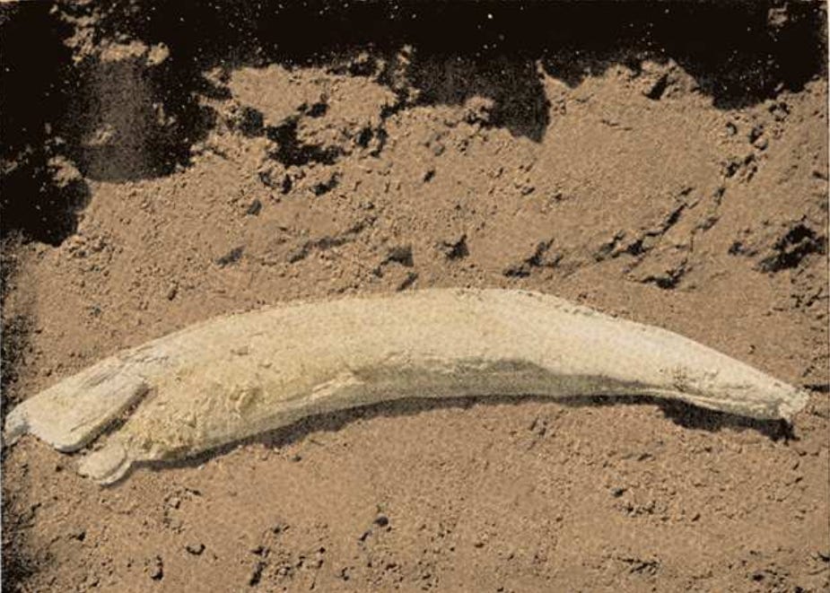
He lists several exports from Adulis, chief among them being ivory, which he notes was shipped in large quantities, suggesting it was the region's primary export. Other goods include rhinoceros horn, hippopotamus hides, and tortoise shell, likely sourced from the nearby Dahlak Islands. Pliny also mentions "sphingia," a term that appears to be the plural of sphingion37, possibly referring to a type of ape. This could correspond to Papio hamadryas, the same species exported from Punt to Egypt in earlier periods. Finally, he notes the export of slaves, likely prisoners from local conquests, which was a common practice during that era.
Ivory Tusk found at Adulis. Source: Modelling the Local Political Economy of Adulis: 1000 BCE–700 CE, p. 290.
Maritime Trade
A Painting Depicting Elephants During Antiquity by archaeologist, architect, and painter Jean-Claude Golvin. Source
Trade route with Egypt
Pliny also describes how “Ethiopians” engaged in maritime trade with ancient Egyptians. For example, in his writings, he mentions that at the Island of Elephantine, located in Upper Egypt, the Ethiopians would leave their boats and carry them to avoid the rocks at each cataract.
Ethiopians as described by Pliny The Elder, described a people group/ “race” that lived South of Egypt, in present day Sudan, Eritrea, Ethiopia , the largest city and proposed capital was Meroe
As previously mentioned, the term Aethiopian was used as a broad label for dark-skinned peoples south of Egypt. At the time, Meroe was the dominant power and thus became the primary reference for Aethiopia. Similarly, following the fall of Meroe to the Aksumite Empire in the late 3rd century AD, the Aksumite Empire and its surrounding region gradually came to be identified as "Ethiopia" by the Greco-Romans foreigners.
This is akin to using the word “North East-African” today.
“ Aristocreon says that the distance from Elephantis to the sea is 750 miles; Elephantis being an inhabited island four miles below the last Cataract, sixteen beyond Syene, 585 from Alexandria, and the extreme limit of the navigation of Egypt. To such an extent as this have the above-named authors been mistaken! This island is the place of rendezvous for the vessels of the Aethiopians: they are made to fold up, and the people carry them on their shoulders whenever they come to the Cataracts.” -Pliny The Elder “Natural History", Book 5, Chapter 10, Section 4
Map showing Elephantine Island and the several cataracts. Source
It is highly likely that trade with Egypt also took place via an inland route, utilising the Nile’s tributaries and navigating through its cataracts. This route was probably established as far back as the Puntite period. The native inhabitants of the region — whether from Meroe, the Troglodytae, Adulis, or Aksum — likely used this inland corridor alongside the maritime routes of the Erythraean Sea.
Early Adulis Boats
What these simple vessels might have looked like, from an Abyssinian Manuscript produced during the Abyssinian Renaissance.
Pliny also describes some of the vessels used for maritime activities. Specifically, he details how cinnamon was acquired by the Aethiopians and then traded across the sea using simple boats that lacked sails or oars, relying instead on the natural winds to guide them across the Arabian seas. In return, they received goods such as glass and copper, and highly demanded items like necklaces, bracelets etc. The excerpt reads as follows:
“all these stories being false, inasmuch as cinnamomum, which is the same thing as cinnamon, grows in Ethiopia, which is linked by intermarriage with the Cave-dwellers. The latter buy it from their neighbours and convey it over the wide seas in ships that are neither steered by rudders nor propelled by oars or drawn by sails, nor assisted by any device of art: in those regions only man and man's boldness stands in place of all these things. Moreover they choose the winter sea about the time of the shortest day, as an east wind is then chiefly blowing. This carries them on a straight course through the bays, and after rounding a cape a west-north-west wind brings them to the harbour of the Gebbanitae called Ocilia. On this account that is the port most resorted to by these people, and they say that it is almost five years before the traders return home and that many perish on the voyage. In return for their wares they bring back articles of glass and copper, clothing, and buckles, bracelets and necklaces; consequently that traffic depends principally on having the confidence of the women” - Pliny The Elder “Natural History", Book 12, Chapter 42, Section 1
Although Adulis had its own inhabitants, known as the Adulitae or Adulites, its role as a merchant city attracted a diverse range of peoples. Traders from across north-east Africa gathered there, along with Egyptians, Romans, South Arabians, and Persians etc...
Gebbanitae were likely a group in Southern Arabia, next to the Sabaeans and Hydramiates38. Ocelis is located near the Bāb al‑Mandab strait and was frequently used to set sail onwards to India39. The fact that it takes nearly five years for merchants from Adulis to return suggests they were travelling vast distances, possibly as far as India. These merchants returned with glass and copper, clothing, and buckles, bracelets and necklaces. As we will see later, the Periplus Of The Erythraean Sea will also mention these same imports.
As mentioned earlier, by around 500 AD, Cosmas confirms that merchants from Adulis were present in Sri Lanka. Therefore, it is not far-fetched to consider that Adulite merchants may have been undertaking such extensive journeys even earlier.
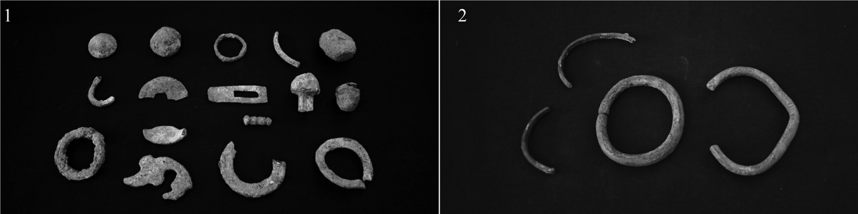
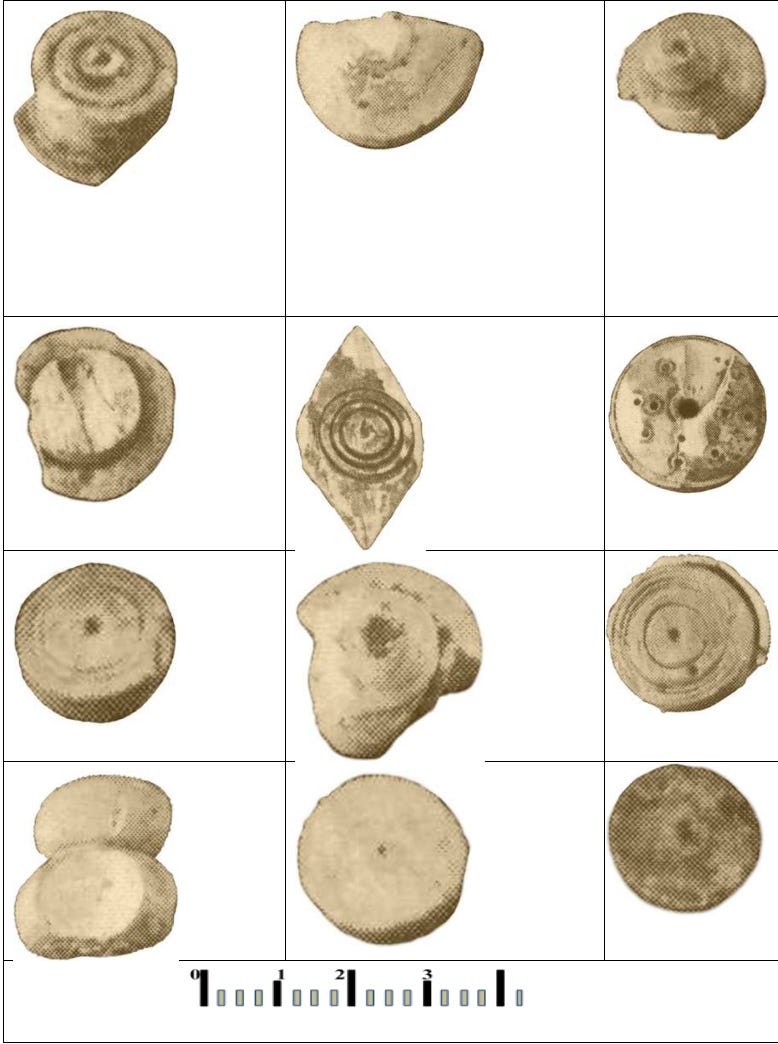
Bronze Rings and Bracelets (Among Other Items) Found at Adulis *Source: The Ancient Red Sea Port of Adulis and the Eritrean Coastal Region: Previous Investigations and Museum Collections, p. 75.
“Consequently, that traffic depends principally on having the confidence of the women" — this may suggest that long-distance trade by the Adulites was, in part, driven by the desires of local women for ornaments such as bracelets and necklaces. Over time, such items became integral to women's dress in the region. To this day, jewellery, necklaces, bracelets, earrings, and more remain an essential part of women's attire and cultural expression in the region…
From left to right: a Tigrinya woman, Afar women, two Tigre women, a Hadendawa Beja woman . Take note of the distinctive jewellery each is wearing.
Markets In Adulis
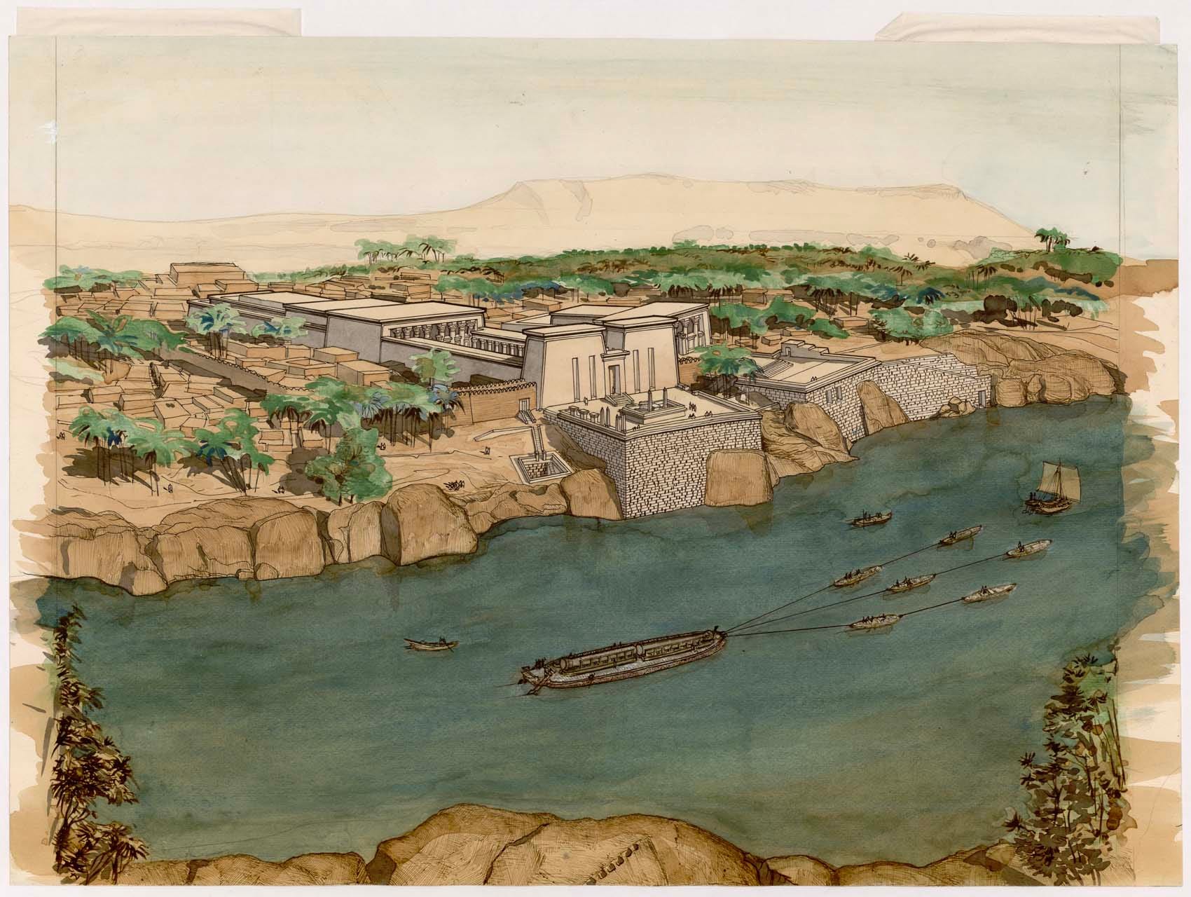
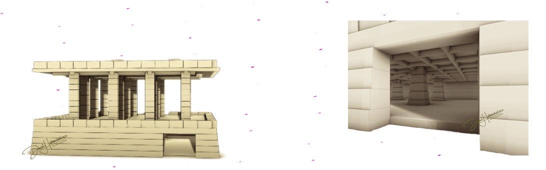
Left: Reconstruction of a trading market building by Dr Daniel Habtemichael Right: My own AI-assisted colourisation of the market scene
So, where did merchants unload their textiles, raw materials, and other goods after docking at the port of Gabaza? And where did traders from Adulis, Aksum, and neighbouring regions bring their goods for exchange?
Much of this commercial activity likely took place in and around the markets of Adulis. One such market has been identified through archaeological excavations led by Dr Daniel Habtemichael. The structure was made from stone and measured approximately 18.12 by 15.40 metres, with remnants of roof-supporting pillars and a lower storage level for goods40. Multiple examples of this market type have been uncovered at Adulis.
These structures differ from those in places like Qohaito in their size. While Qohaito's markets typically featured two-pillared designs41, those at Adulis had four, reflecting the higher trade volume that Adulis handled as a major Red Sea port.
The interior storage area beneath the Market. Created by Dr. Daniel Habtemichael. Source
Archaeologists estimate that about 70 percent of all ancient coins discovered in the northern Horn of Africa have been unearthed at Adulis42.
Periplus of the Erythraean Sea (~50AD-~100AD)
Names, routes and locations of the Periplus of the Erythraean Sea. Source
Περίπλους τῆς Ἐρυθρᾶς Θαλάσσης (Periplous tēs Erythrâs Thalássēs) breaks down as follows:
Περίπλους (Periplous) → from peri- (around) + -plous (sailing), meaning “a sailing around” or “voyage”
τῆς (tēs) → “of the”
Ἐρυθρᾶς (Erythrâs) → feminine form of the word “red”
Θαλάσσης (Thalássēs) → feminine form of the word “sea”
Altogether, Περίπλους τῆς Ἐρυθρᾶς Θαλάσσης translates to “Voyage of the Red Sea”.
The term Periplous refers to a genre of ancient Greco-Roman texts that listed coastal ports, trade hubs, and general sailing directions. Helping sailors and merchants navigate foreign waters, the Periplus of the Erythraean Sea was one such document.
Modern-day Eritrea (Greek: Ἐρυθραία → Erythraía) derives its name from the Erythraean Sea, the ancient Greek term for the Red Sea.
The Periplus of the Erythraean Sea, whose author is unknown, is generally dated between 40 and 70AD43 (Scholar Wilfred Harvey Schoff proposed a more specific date of around 60 AD44). Despite the uncertainty surrounding its authorship, the text offers a detailed account of Adulis—its trade, surrounding territories, ruling authority, and the extent of that ruler’s domain. I will begin by presenting an excerpt concerning the trade and territorial context of Adulis:
“Below Ptolemais of the Hunts, at a distance of about three thousand stadia, there is Adulis, a port established by law, lying at the inner end of a bay that runs in toward the south. Before the harbor lies the so-called Mountain Island, about two hundred stadia sea-ward from the very head of the bay, with the shores of the mainland close to it on both sides. Ships bound for this port now anchor here because of attacks from the land. They used formerly to anchor at the very head of the bay, by an island called Diodorus, close to the shore, which could be reached on foot from the land; by which means the barbarous natives attacked the island. Opposite Mountain Island, on the mainland twenty stadia from shore, lies Adulis, a fair-sized village, from which there is a three-days' journey to Coloe, an inland town and the first market for ivory...” - Periplus of the Erythraean Sea, section 4
Ὀρεινὴ is the exact Greek word used in the Periplus, which Wilfred Harvey Schoff translated as "Mountain Island." It derives from the ancient Greek word ὄρος, meaning "mountain”.
Locations
Map of Adulis and Surrounding Regions (Samidi → Samidi; Galala Hills → Port of Gabaza; East of Galala Hills → Diodorus Island) Source: The Ancient Red Sea Port of Adulis, Eritrea Results of the Eritro-British Expedition, 2004-5, Figure 5.2.
As discussed earlier, Ptolemais of the Hunts was a port founded by Ptolemy II, located near the Gulf of ʿAqīq in present-day Sudan45. The Periplus later refers to Adulis as a port “established by law”, indicating that it was under the control of a formal government or legitimate authority (we will see later who this authority likely was). It is described as lying deep within the gulf; however, this is not entirely accurate, as Adulis is situated much further north, as can be seen in the map above. This discrepancy may simply be a minor geographic error, or it could reflect environmental changes, such as coastal shifts from flooding, over the past two millennia.
Adulis was one of only three ports along the entire Erythraean Sea route designated as “established by law” (νόμιμον → comes from the root νόμος → nómos, meaning law46), meaning the safety of traders and merchants was guaranteed upon arrival47.
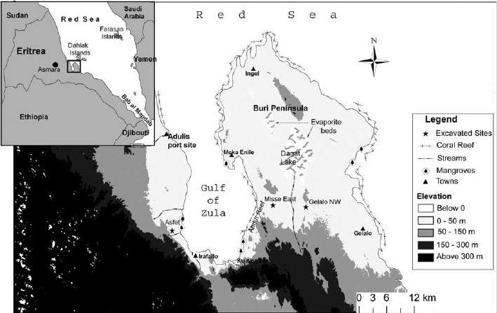
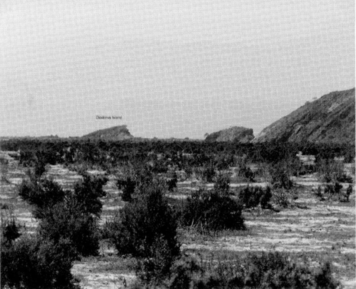
The phrase “Mountain Island” (Ὀρεινὴ) likely refers to Dese Island48, located just off the coast of the Buri Peninsula. Based on my rough measurements online, the distance from the head of the bay to this island is approximately 44 km, or around 200 stadia, which aligns with the figure mentioned in the Periplus. In contrast, the location of the “Island of Diodorus” isn’t entirely known; some scholars speculate that it may have disappeared due to siltation49, while archeologists David Peacock & Lucy Blue speculate it was west of the Galala Hills, as analysis found that the area could have been surrounded by sea & many fragments foreign & local pottery were found here50.
View Of “Diodorus Island”. Source: The Ancient Red Sea Port of Adulis, Eritrea Results of the Eritro-British Expedition, 2004-5, Figure 4.3
The author of the Periplus also notes that native groups attacked vessels docking at the head of the bay. This may suggest that not all areas within the Gulf of Zula were governed by the same laws that applied to Adulis itself. Regions further from the port, such as the area around “Mountain Island”, may have been home to autonomous tribes or communities that operated independently of Adulis’ legal authority at certain periods.
Another possibility is that neighbouring tribes were permitted to act with hostility towards foreign merchants if existing trade agreements had expired/breached etc...
Inland trade
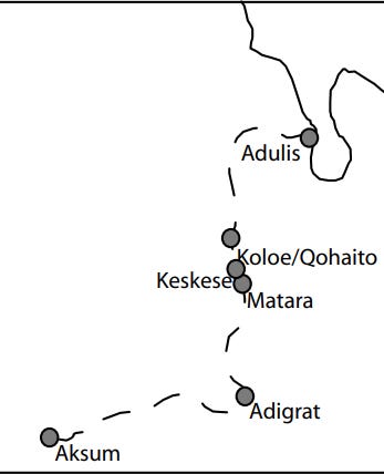
A map illustrating the route from Adulis to Aksum, passing through urban settlements. (The Ancient Red Sea Port of Adulis and the Eritrean Coastal Region, pg, 4)
“….Opposite Mountain Island, on the mainland twenty stadia from shore, lies Adulis, a fair-sized village, from which there is a three-days' journey to Coloe, an inland town and the first market for ivory. From that place to the city of the people called Auxumites there is a five days' journey more; to that place all the ivory is brought from the country beyond the Nile through the district called Cyeneum, and thence to Adulis. Practically the whole number of elephants and rhinoceros that are killed live in the places inland, although at rare intervals they are hunted on the seacoast even near Adulis. Before the harbor of that market-town, out at sea on the right hand, there lie a great many little sandy islands called Alalaei, yielding tortoise-shell, which is brought to market there by the Fish-Eaters.” - Periplus of the Erythraean Sea, section 4
Next, the text reveals the inland trade route used by merchants from Adulis, which is described as a "κώμη σύμμετρος" (a fair-sized village). This route leads to Coloe (likely modern Qohayito), which is designated as a "πόλιν" (a form of "πόλις” - Polis, meaning city-state); the designation of town is erroneous. Scholars like J. W. McCrindle translated it as a city (see section 4 here). This classification for Coloe is logical, given its location in the more temperate highland climate, which would have supported more robust agriculture. Such conditions foster the development of larger state formations, supporting a greater population and a more complex society, hence a city. Coloe's advantageous position as the first highland destination from Adulis significantly contributed to its growth. The passage then states that it's a further five-day journey from Coloe to the "μετρόπολιν" (metropolis) of the Aksumites, implying it was their principal and largest city of the Aksumite people, likely referring to Aksum itself.
Exports
Ivory Artifacts found in Adulis - Modelling the Local Political Economy of Adulis, pg 291
The text lists the region's main exports as elephants and rhinoceros, confirming Pliny's earlier accounts. Notably, the Periplus author mentions elephants could be found near Adulis - quite different from today, when elephants survive only in small numbers in Eritrea's western Gash-Barka region.
The author then describes many "sandy islands" called Alalaei, referring to the Dahlak Islands51. These islands were valued for their tortoise shells, which were also documented by Chinese historians during the Han Dynasty (as we will see later…).
Finally, "Fish-eaters" (Ichthyophagoi) was a Greek-Roman term for various coastal peoples whose diet was mainly fish. In the Periplus, it refers to an unknown group living near the coast who hunted tortoise shells (possibly the Dahlak people???).
The King Of The Erythraean Sea: Zoskales (Ζωσκάλης)
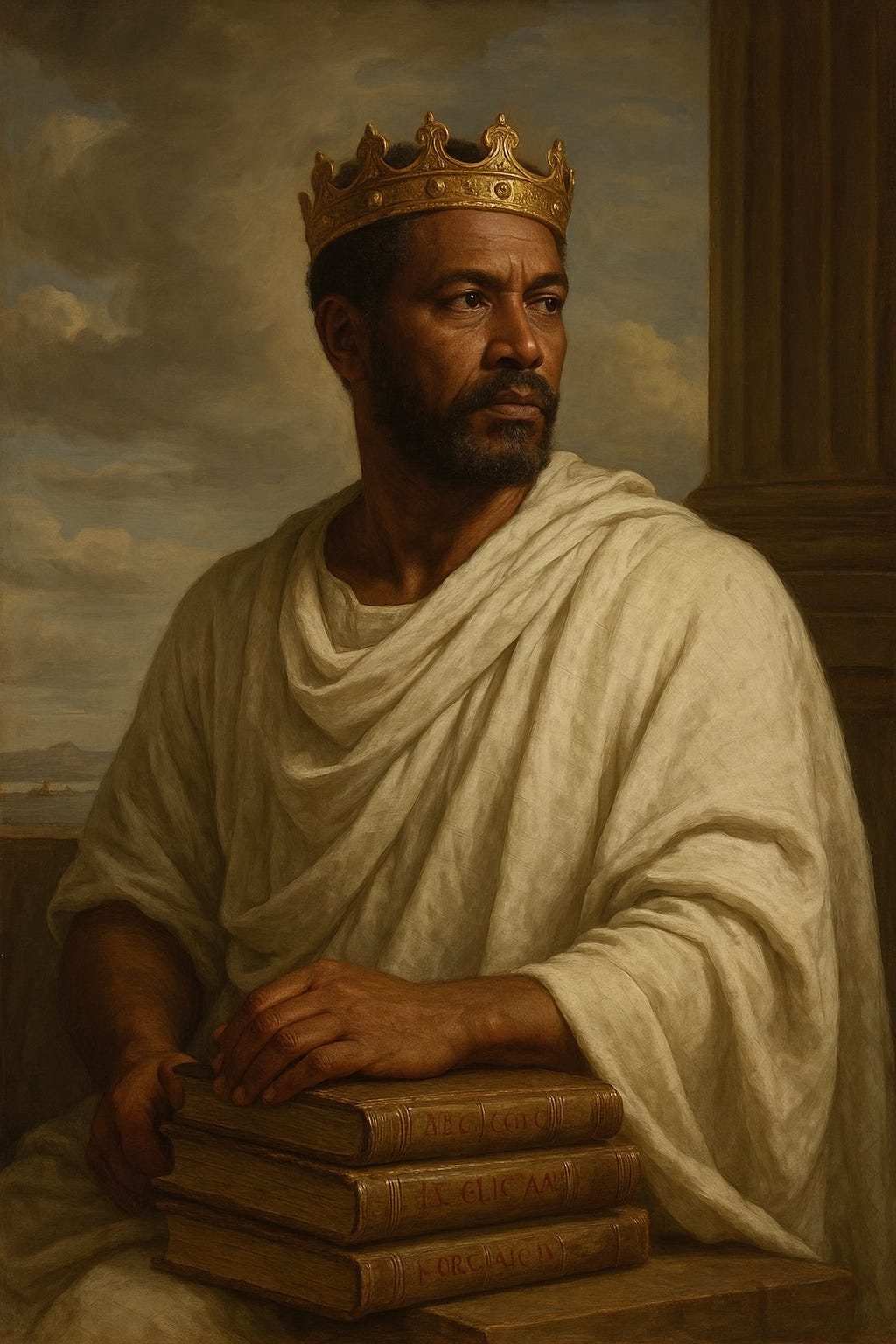
AI-Assisted Artwork Of Emperor Zoskales (Own Work).
The Periplus then provides a rare glimpse into one of the earliest known rulers in the region during antiquity (outside of DM`T): a man named Zoskales. Interestingly, his character is detailed as follows:
“Zoscales, precise in his life and greatly ambitious, but otherwise noble and skilled in Greek letters”
He is described as ἀκριβὴς (from ákros, meaning precise or sharp52). This term has been translated by scholars like J. W. McCrindle and Wilfred Harvey Schoff as "penurious" or "miserly" (stingy). This interpretation might stem from the Greek word δὲ(dé, meaning “but”53) being used later in the description, suggesting a contrasting or excessive quality to his precision, perhaps specifically in financial dealings, given Adulis's focus on trade.
Furthermore, Zoskales is characterised as ἐξεχόμενος (the passive form of ἐξέχω, meaning "standing out"54), implying a prominence or ambition. He is also noted as γενναῖος (gennaîos, meaning noble55), and importantly, Ἑλληνικῶν ἔμπειρος (Hellēnikōn56 (knowing greek) empeiros57 (Experienced)), signifying his experience and skill in Greek matters & literature.
His proficiency is entirely understandable. Koine Greek58 served as the lingua franca for trade and administration across Asia Minor and Egypt (and the surrounding areas) during antiquity, facilitating commercial activities. Adulis, as previously noted, maintained strong ties with the Hellenistic world, evidenced since the time of Ptolemy II and III and the Basilt Stele. Thus it’s unsurprising that the local nobility, such as Zoskales, were proficient in Greek.
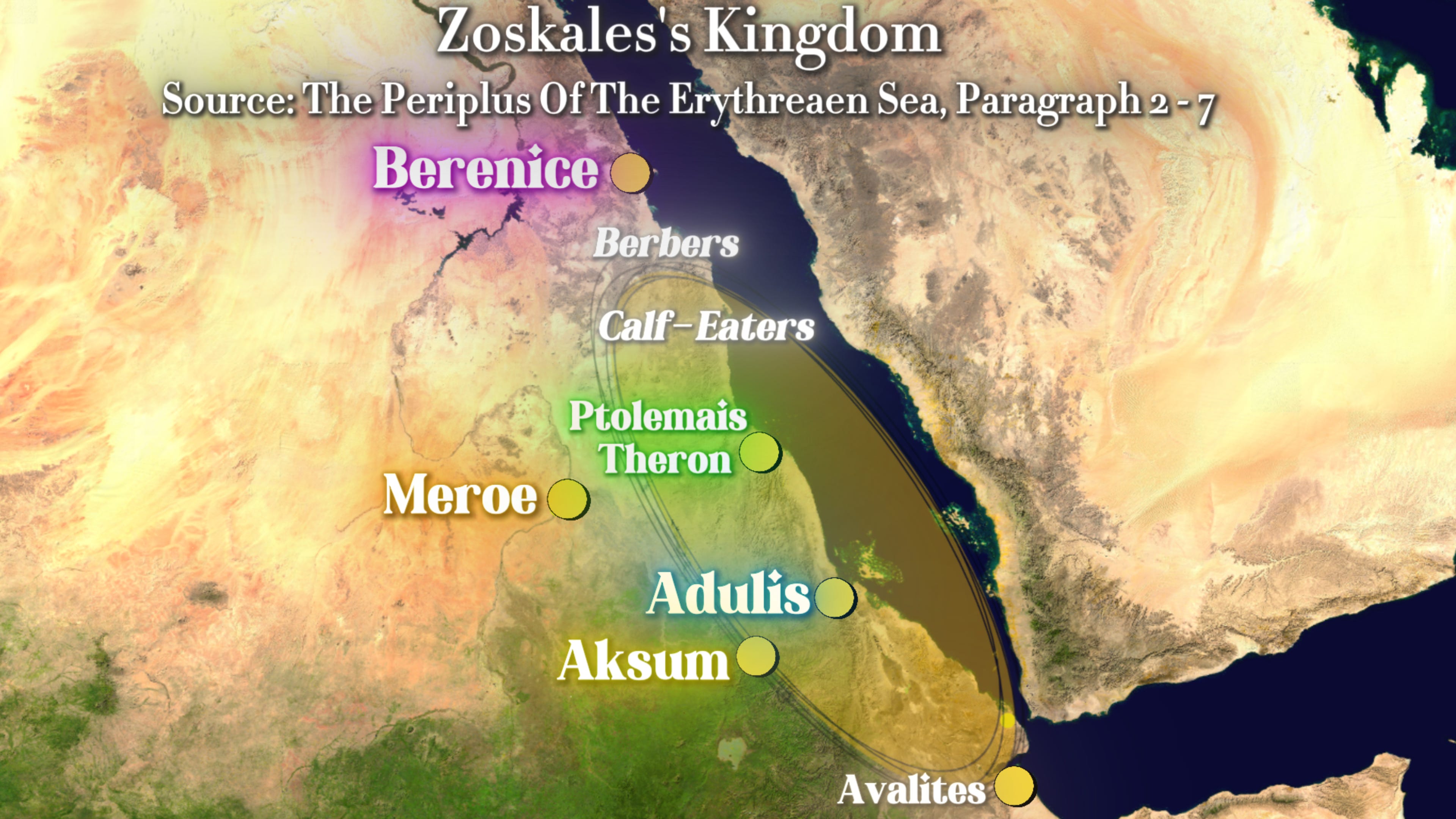
Approximate Map of Zoskales’s Kingdom Based on The Periplus of the Erythraean Sea (Paragraphs 2–7) – Own Work.
The Periplus also outlines the territorial extent of Zoscales's dominion, suggesting his rule encompassed diverse peoples. The text describes his realm as stretching from the "Calf-Eaters" (Μοσχοφάγων, meaning Moschos "calf" + Phagos "eater"59) to the "other Berber country”.
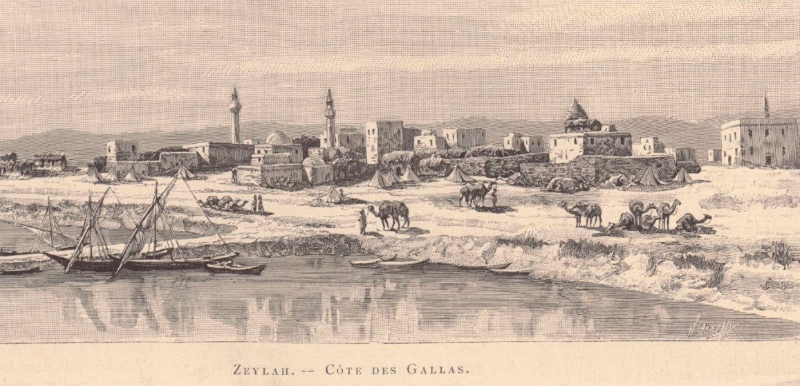
These "Calf-Eaters" were likely nomadic pastoralists whose diets centred on cattle, possibly a subgroup of the Beja people. Geographically, they were situated south of the Berbers (Barbaroi), who in turn lived south of Berenice (the southernmost tip of Ptolemaic and Roman Egypt) and north of Ptolemais of the Hunts (mentioned earlier as being near modern-day Aqiq). Zoscales's territory extended as far south as the "other Berbers," located just past the narrowest point of the Bab el Mandeb strait (near modern-day Zeila). The full excerpt detailing this is as follows:
“On the right-hand coast next below Berenice is the country of the Berbers [Barbaroi]. Along the shore are the Fish-Eaters [Ichthyophagoi], living in scattered caves in the narrow valleys. Further inland are the Berbers, and beyond them the Wild-flesh-Eaters and Calf-Eaters, each tribe governed by its chief; and behind them, further inland, in the country toward the west, there lies a city called Meroe.
Below the Calf-Eaters there is a little market-town on the shore after sailing about four thousand stadia from Berenice, called Ptolemais of the Hunts, from which the hunters started for the interior under the dynasty of the Ptolemies. This market-town has the true land-tortoise in small quantity; it is white and smaller in the shells. And here also is found a little ivory, like that of Adulis. But the place has no harbor and is reached only by small boats.
…..
And about eight hundred stadia beyond there is another very deep bay, with a great mound of sand piled up at the right of the entrance; at the bottom of which the opsidian stone is found, and this is the only place where it is produced. These places, from the Calf-Eaters to the other Berber country, are governed by Zoskales, who is miserly in his ways and always striving for more, but otherwise upright, and acquainted with Greek literature.
……
From this place the Arabian Gulf trends toward the east and becomes narrowest just before the Gulf of Avalites. After about four thousand stadia, for those sailing eastward along the same coast, there are other Berber market-towns, known as the "far-side" ports;”
First, it’s important to understand the unit of measurement mentioned in the text: the stadia (plural of the Greek στάδιον or Stadion60). This was an ancient Greek unit of length, typically around 600 feet61, or approximately 183 metres, though it varied slightly at times. We will use this measurement to help verify the locations described in the Periplus of the Erythraean Sea as being under Zoskales’ domain.
The word Stadium derives from the word stadia.
From Berenice to Aqiq
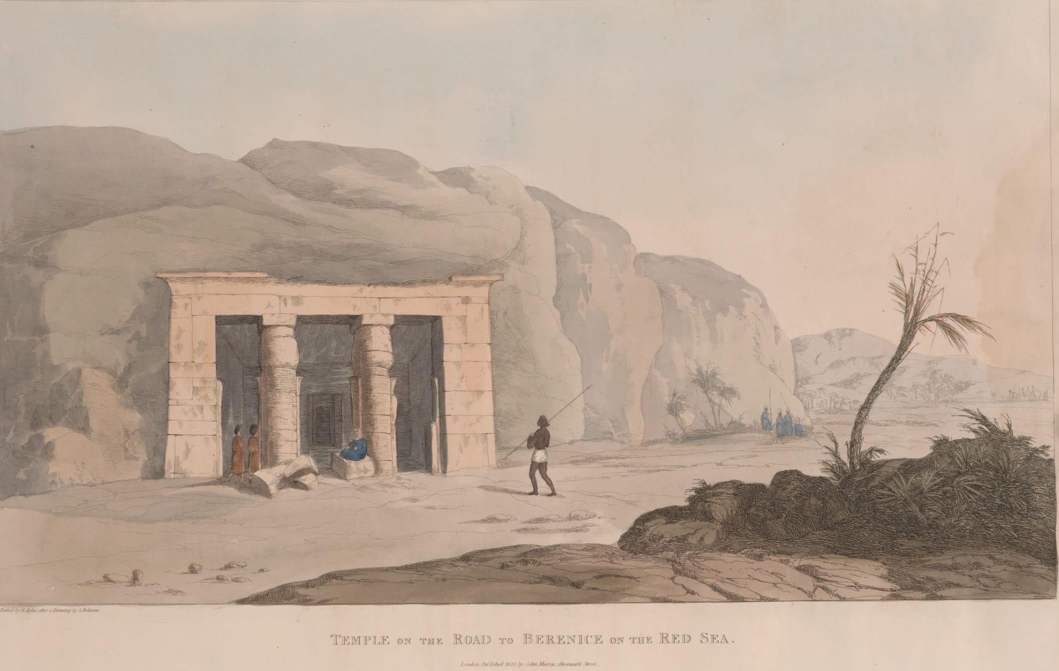
18th century Artwork titled “Temple on the road to Berenice [Baranis] on the Red Sea”. Source
Berenice is named after Ptolemy II Philadelphus mother.
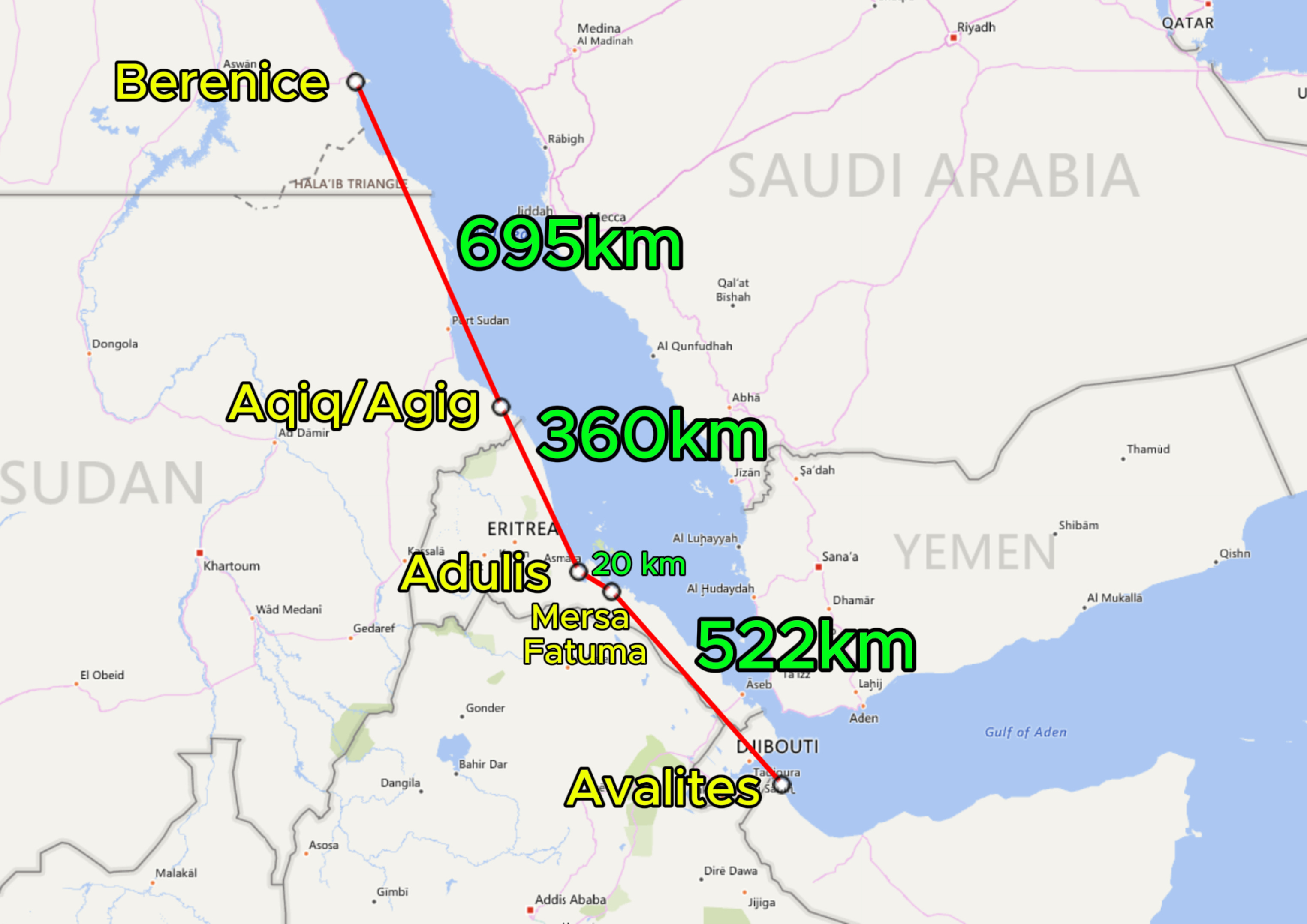
First, the Periplus mentions Berenice, located in the far south of modern-day Egypt. It then describes the next destination, Ptolemais of the Hunts (previously identified as Aqiq, Sudan), as being four thousand stadia away, equivalent to 732 km. When I measured the distance today, it was approximately 695 km — remarkably close to the original estimate.
Ptolemais of the Hunts to Adulis
A 19th-century engraving of Temple B at Adulis. Source
It then states that from Ptolemais of the Hunts to Adulis is another 3,000 stadia, which is roughly 549 km. As shown on the map, the distance from Aqiq to Adulis today is approximately 360 km (or up to 380–390 km if considering the innermost part of the Gulf of Zula). This leaves a discrepancy of about 200 km, or roughly 1,000 stadia. Since the location of Adulis is well established, this might suggest that either Aqiq was located slightly further north than today’s position, or the author of the Periplus made a rough estimate. The Greek word ὡς (hos)62, when placed before a number (as with the 3,000 stadia), typically indicates an approximation63, making such margins of error over long distances acceptable.
Adulis To The Obsidian Source
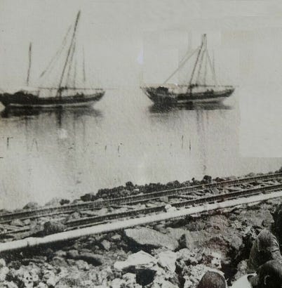
Mersa Fatma during the period of Italian colonisation of Eritrea. Source
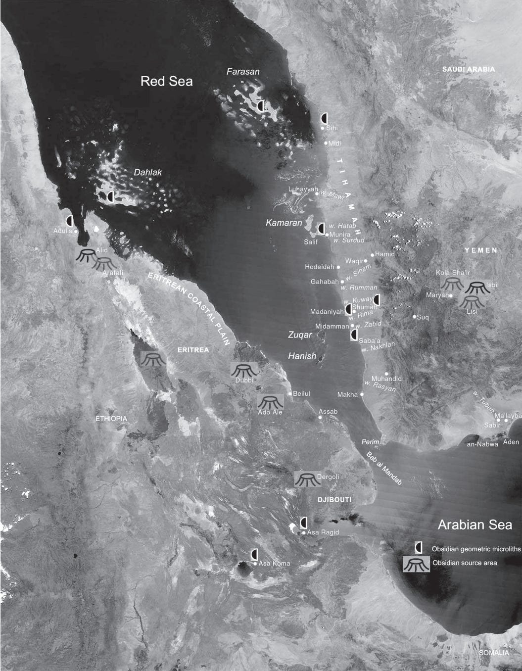
The Periplus then describes a deep bay where obsidian was sourced. This location, approximately 800 stadia — or roughly 120 to 160 kilometres from the previous point, which may correspond to modern-day Mersa Fatuma, which lies around 20 kilometres from Adulis and is situated near two known obsidian deposits.
Map showing sources of Obsidian in Eritrea, Djibouti & Yemen. Source: Holocene Obsidian Exchange in the Red Sea Region, page 19.
Interestingly, the text claims this was the only site where obsidian was mined. While this may reflect the limited knowledge of the Greek author rather than absolute fact, it was likely one of the primary centres for obsidian extraction. Its proximity to Adulis, where obsidian was used in construction, likely contributed to this.
Mersa Fatma would later serve as a small port for the Italians during the colonial era and as a site for potash mining, prior that oral tradition states that locals warded of Abyssinian encroachment for sea-access64.
Lastly, the Periplus mentions that from Adulis to the first "Other-Berber" market town, called Avalites, is 4,000 stadia (approximately 732 km). Scholars have suggested that Avalites corresponds to modern-day Zeila65. My own measurements place the distance from Adulis to Zeila at roughly 522 km.
Zoskales’s Residence
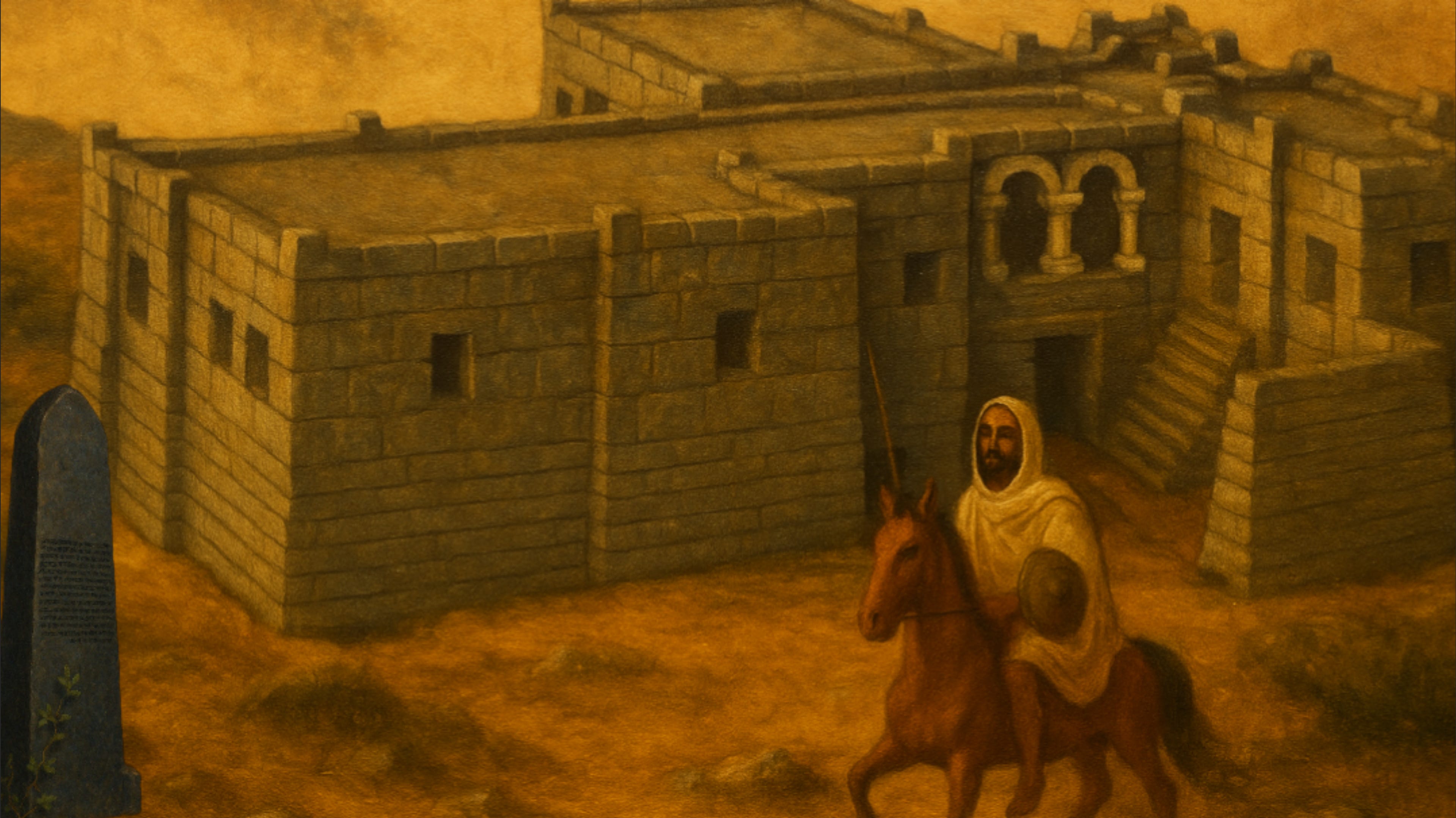
Zoskales in front of the king’s palace at Adulis; to the left stands the basalt stele. Source: Own Work.
Dr Daniel Habtemichael’s website provides extensive details on the architecture of Adulis, featuring numerous models—definitely worth checking out (click the button above).
There has been much scholarly speculation regarding the residence of Zoskales. However, most recent academic works — including those by D. W. Phillipson66, Chiara Zazzaro67, and Andrea Manzo68 — suggest that he most likely resided at Adulis. The evidence for this is twofold: first, the Periplus opens by focusing on Adulis rather than Aksum; therefore, the mention of Zoskales falls within the context of Adulis. At the time, Aksum was still in its developmental stages, whereas Adulis had already existed for several centuries, if not longer. That said, the exact residence of Zoskales cannot be determined with absolute certainty69. While Aksum is later referred to as a metropolis, the dating of the Periplus to the 1st century AD makes Adulis the more probable seat of his rule.
If Zoskales did govern from Adulis and controlled such an extensive trade network, it is reasonable to assume that he maintained some form of royal palace there….
The Palace
Conceptual Drawing Of The King Residence In Adulis by Dr Daniel Habtemichael. Source
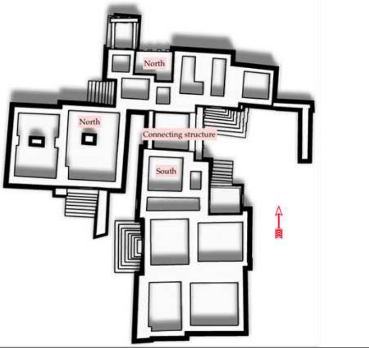
Originally excavated by the Ethiopian Institute of Archaeology in 1961–62, the "King's Residence" at Adulis is a single-storey structure divided into northern and southern sections, connected by a central room. The building was constructed using stone blocks, finely cut and dressed by skilled stonemasons. It featured three staircases leading to entrances: one at the southern end, and two on the northern side (situated on the south and east walls). The southern section also had an entrance on its western wall70.
From the left: North-Southeast corner entrance, Northwest entrance, Southwest wall entrance.. Source: Modeling the Local Political Economy of Adulis: 1000 BCE-700 ACE, pg 225-226.
In total, the structure contained approximately 16 rooms. A small exterior wall likely stood near the entrance, while a balcony adorned with decorative arches and pillars. Over 550 artefacts71 were discovered within the building during the excavation process, including the large elephant tusk shown previously in this article.
Dr Daniel Habtemichael, notes multiple stories might be possible but excavations are at a very early stage currently.
Floor Plan by Dr Daniel Habtemichael of the Kings’ Residence - Source: Modeling the Local Political Economy Of Adulis, pg 222
Architectural Remains of the Kings’ Residence - Source: Modeling the Local Political Economy Of Adulis, pg 413
Trade At Adulis During the First Century AD
The author of the Periplus discusses the trade that took place in this region. He specifically mentions the items imported into the region and provides a brief overview of what was exported. This information offers valuable insights into what the people in Zoskales' domain & those living even deeper in the hinterland valued and desired.
“There are imported into these places, undressed cloth made in Egypt for the Berbers; robes from Arsinoe; cloaks of poor quality dyed in colors; double-fringed linen mantles; many articles of flint glass, and others of murrhine, made in Diospolis; and brass, which is used for ornament and in cut pieces instead of coin; sheets of soft copper, used for cooking-utensils and cut up for bracelets and anklets for the women; iron, which is made into spears used against the elephants and other wild beasts, and in their wars. Besides these, small axes are imported, and adzes and swords; copper drinking-cups, round and large; a little coin for those coming to the market; wine of Laodicea and Italy, not much; olive oil, not much; for the king, gold and silver plate made after the fashion of the country, and for clothing, military cloaks, and thin coats of skin, of no great value. Likewise from the district of Ariaca across this sea, there are imported Indian iron, and steel, and Indian cotton cloth; the broad cloth called monache and that called sagmatogene, and girdles, and coats of skin and mallow-colored cloth, and a few muslins, and colored lac. There are exported from these places ivory, and tortoise-shell and rhinoceros-horn. The most from Egypt is brought to this market from the month of January, to September, that is, from Tybi to Thoth; but seasonably they put to sea about the month of September.” - The Periplus Of The Erythreaen Sea, Paragraph 6
The cultural exchange in clothing between Adulis, Greece, and India was significant during antiquity. This excerpt, along with others in the article, offers only a brief glimpse into the interactions that occurred during this era…
Clothing and Textiles
A depiction of the city of Arsinoe in Assassin’s Creed Origins. Source
Arsinoe is named after Ptolemy II Philadelphus wife.
The author of the Periplus notes that clothes were commonly imported from Egypt, particularly robes from Arsinoe, a city situated near the Gulf of Suez at the northern end of the Red Sea72. Additionally, linen mantles were another form of clothing mentioned. These mantles were essentially garments made from linen and wool, with cloaks that covered the head, providing both comfort and protection from the sun.
Left: Woman wearing a Zuria, a traditional Habesha dress made of cotton or silk. Right: Ancient Greek woman wearing a himation, made of wool or linen.
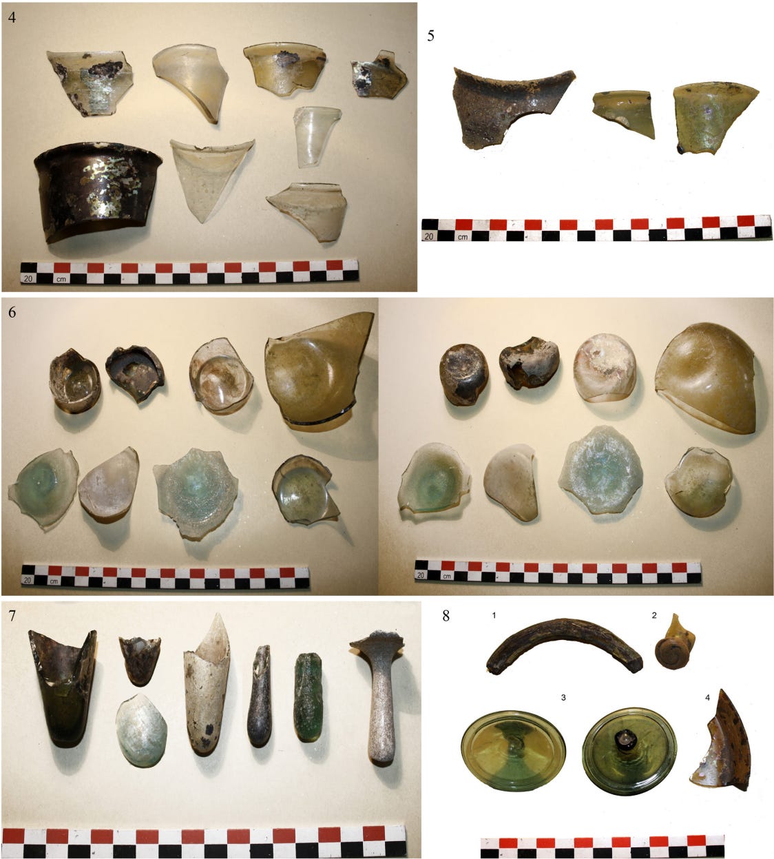
The Periplus also mentions various materials that were imported, primarily from Diospolis — the Greek name for Thebes (Diospolis Magna meaning "Great City of Zeus"73). Once these glass materials arrived, they were further crafted locally for use in architecture, pottery, and other applications. Among them, it specifically refers to what is translated as "Flint glass" (the actual Greek term being λιθίας ὑαλῆς, meaning lithic húelos or "stony glass"). Glass artefacts are frequently found at Adulis, including fragments from what were once bottles, flasks, dishes, bowls, cups, lamps, bracelets, and more.
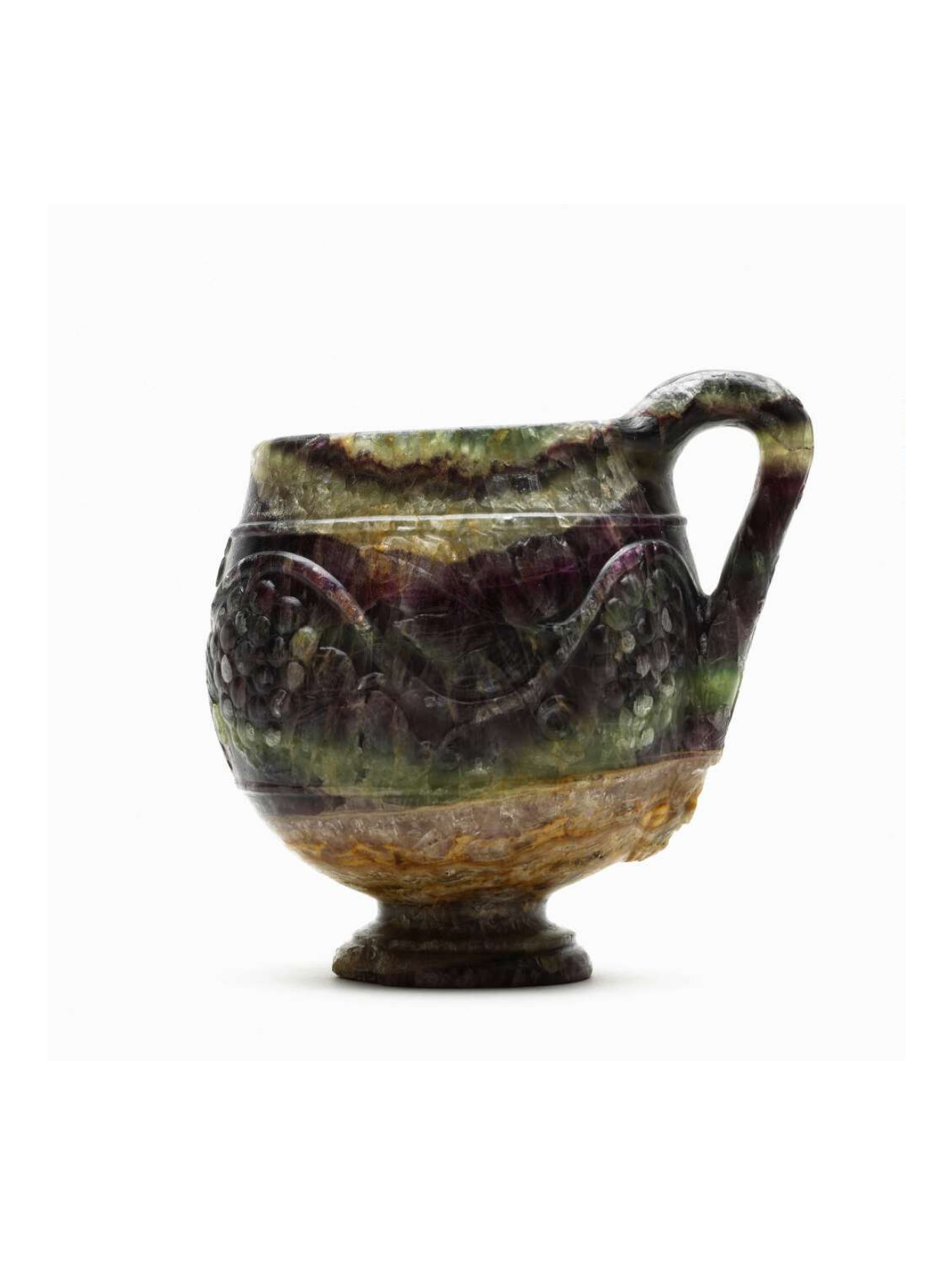
Also imported was murrhine was a mysterious material(maybe made from fluorite74) used in antiquity, often crafted into vases and cups. It was highly valued for its distinctive, often varied colouring, resembling a rainbow of colours, which enhanced its aesthetic appeal. These were likely imported for the nobility.
Cup crafted from Murrhine from 50-100 AD, found in Turkey. Source
Metals
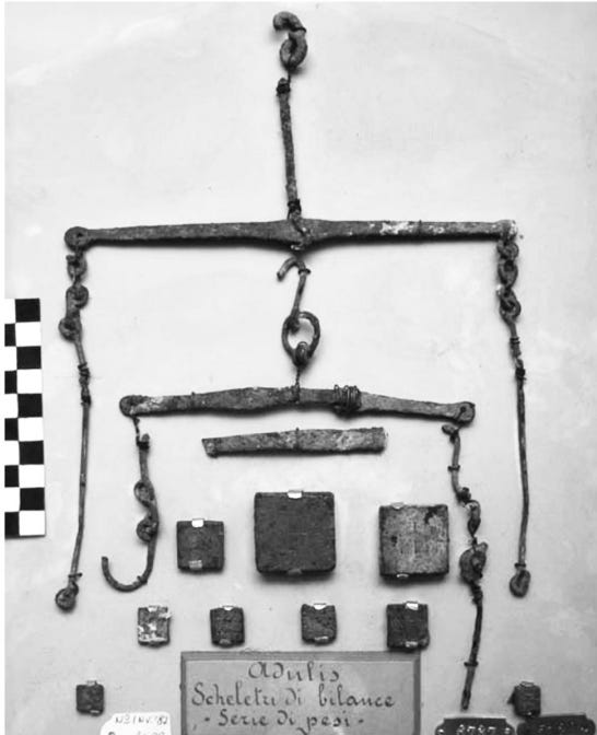
Metals such as brass and copper were imported for a variety of uses, such as to facilitate trade. For example, locals crafted them to create scales for measuring goods and also minted coins75.
Copper Scales Found at Adulis. Source: The Ancient Red Sea Port of Adulis and the Eritrean Coastal Region, pg 78.
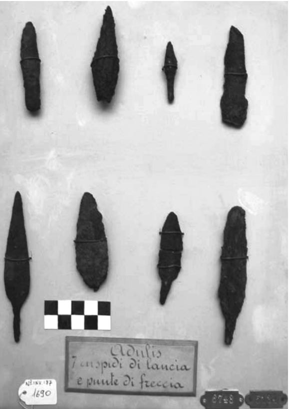
Iron spearheads found at Adulis. Source: The Ancient Red Sea Port of Adulis and the Eritrean Coastal Region, pg 82.
Iron was another significant import mentioned, widely used for crafting spears, essential for warfare and elephant hunting. Iron tools were also discovered, likely intended for medical purposes.
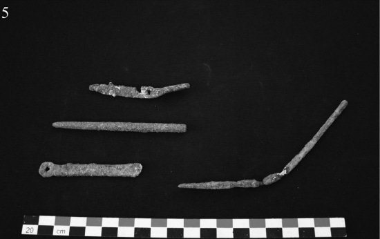
Iron Medical utensils found at Adulis. Source: The Ancient Red Sea Port of Adulis and the Eritrean Coastal Region, pg 75.
Luxury Items
Various ceramic artefacts found at Adulis. Source: The Ancient Red Sea Port of Adulis and the Eritrean Coastal Region.
The text mentions that a limited amount of wine was imported from Laodicea (modern-day Turkey) and Italy, primarily reserved for the royalty, such as King Zoskales and his entourage. These were likely held in ceramic vases such as the ones seen above and served in goblets. Additionally, gold and silver plates, intricately decorated in the cultural styles of the region, were also imported/crafted.
Military Cloaks
Left: Model of an ancient Greek man wearing a chlamys. Right: Photograph of a Kebessa warrior, 1936.
The text also mentions the importing of Military cloaks, likely chlamys (χλαμύς) made of wool, which were commonly worn by soldiers, hunters, horsemen, and travellers in ancient Greece and Rome. Comparable garments were probably adopted by similar groups in Adulis and its surrounding regions. However, given Adulis's warmer climate, cotton may have been favoured instead, resembling the ጋቢ (Gabi), a traditional cotton garment still worn by the Habesha people. The text also refers to coats made from animal skins, likely used for additional protection or by commoners unable to afford silk, similar to the clothing worn by some peasants in the region during the medieval period.
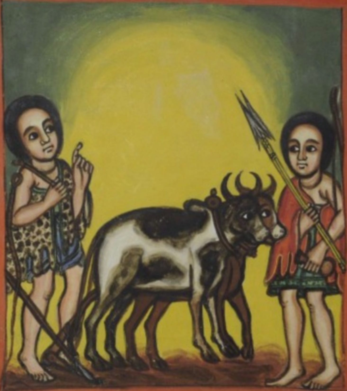
A painting of the “Cannibal of Qemer” from a medieval manuscript made in Gojjam, Abyssinia. Note the clothes that the cannibal and the farmer are wearing…
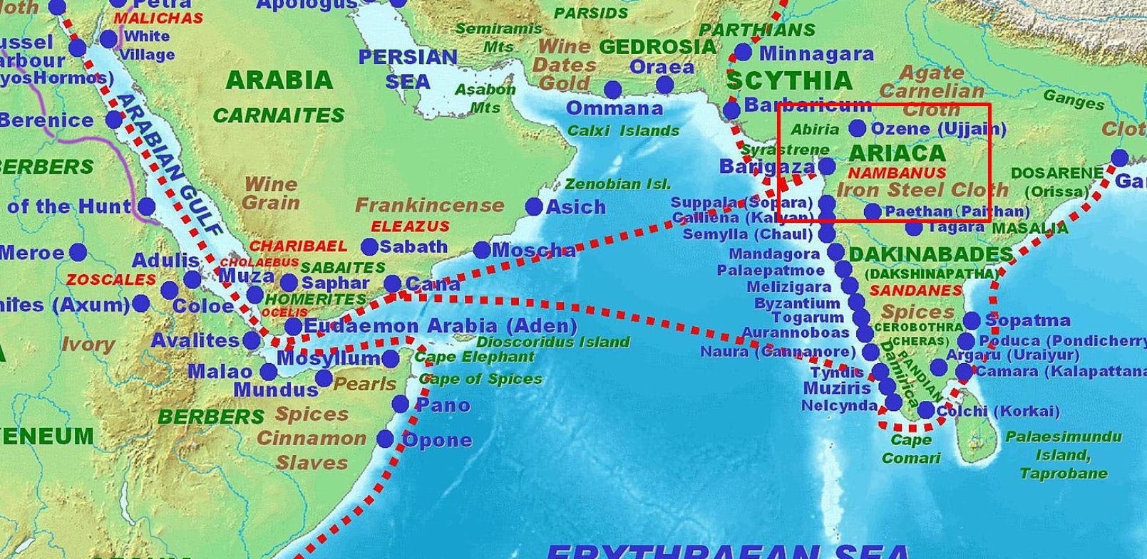
Lastly, the region of Ariaca is mentioned; this region is in ancient India77 (roughly corresponding to parts of modern-day Gujarat, Rajasthan, and Punjab) and was mentioned for its exports to the Red Sea region. In particular, Iron, steel, and cotton were highly sought-after imports. The author also mentions specific textiles, including mallow-coloured (purple) cloth and coloured lac, a reddish dye produced from insects. These fabrics and dyes were valued for their quality and vibrant colours, making them highly prized for colouring clothes & beauty products.
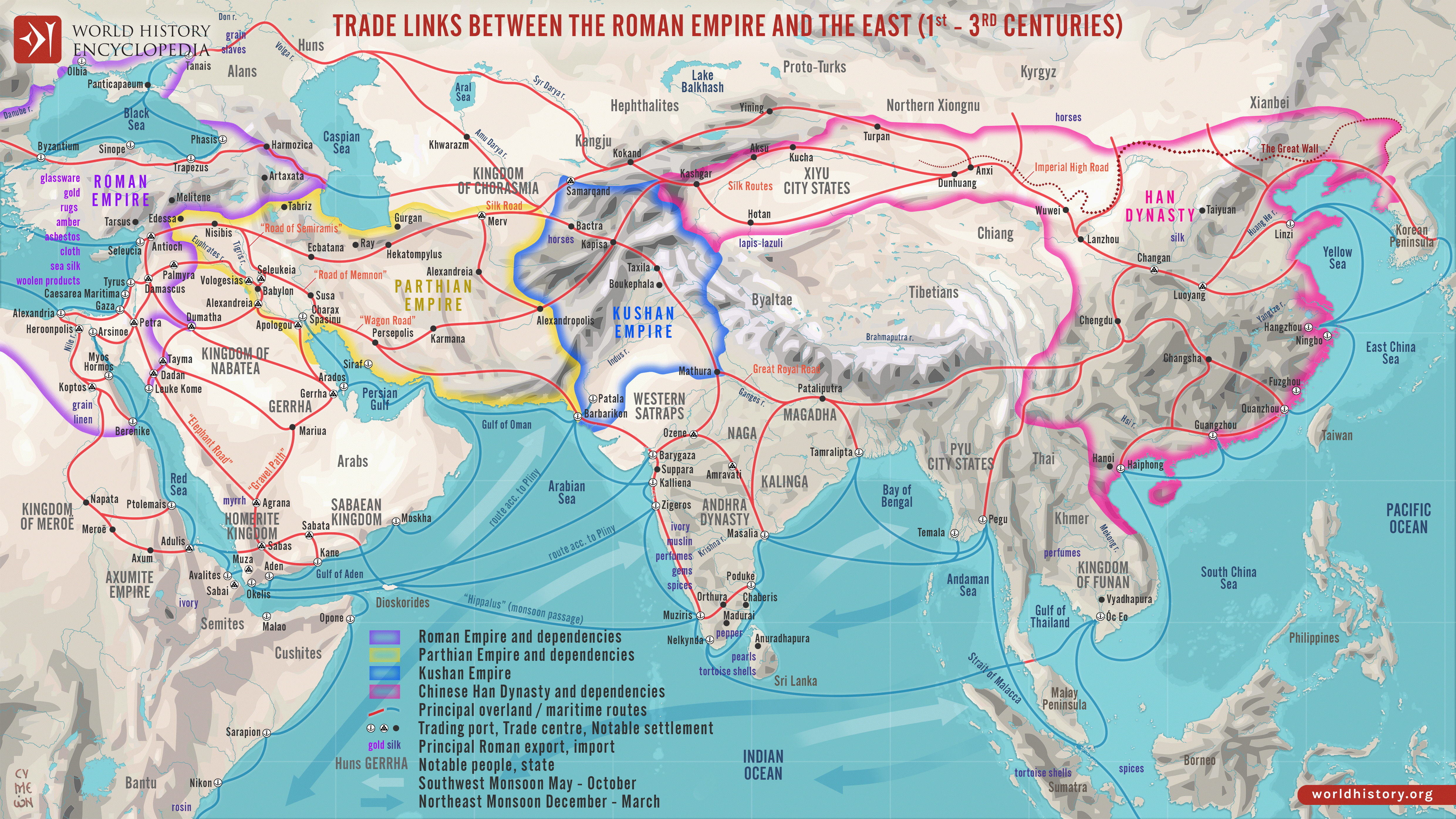
Recent scholarly research has uncovered evidence of contacts between China and Adulis & the surrounding region during antiquity. The earliest reference appears in chapter 28 of the Annals of the Earlier Han Dynasty (206 BC – 24 AD)78, which records that during the reign of Emperor Wu (141–87 BC), following a voyage of twelve months, a distant kingdom called Huang-tschiwas reached and trade was conducted with its inhabitants. Scholars have hypothesised that Huang-tschi refers to the Agazi tribe79.
“ 自日南障塞、徐聞、合浦船行可五月,有都元國;又船行可四月,有邑盧沒國;又船行可二十餘日,有諶離國;步行可十餘日,有夫甘都盧國。自夫甘都盧國船行可二月餘,有黃支國,民俗略與珠劯相類。其州廣大,戶口多,多異物,自武帝以來皆獻見。有譯長,屬黃門,與應募者俱入海巿明珠、璧流離、奇石異物,齎黃金雜繒而往。所至國皆稟食為耦,蠻夷賈船,轉送致之。亦利交易,剽殺人。又苦逢風波溺死,不者數年來還。大珠至圍二寸以下。平帝元始中,王莽輔政,欲燿威德,厚遺黃支王,令遣使獻生犀牛。自黃支船行可八月,到皮宗;船行可八月,到日南、象林界云。黃支之南,有已程不國,漢之譯使自此還矣。” - Book Of Han, Volume 28b: Treatise on Geography 2 (Last Paragraph).
Rough Translation:
“From the frontier at Rinan, Xu Wen, and Hepu, one can sail for about five months to reach the country of Douyuan. From there, another four months by ship leads to the country of Yilu Mo. A further voyage of over twenty days brings one to the country of Shenli. After walking for over ten days, one arrives at the country of Fugandulu. From Fugandulu, sailing for more than two months brings one to the country of Huangzhi (Huang-tschi). The customs of its people are somewhat similar to those of the people of Zhuyai (Pearl Cliffs).
This region is vast, densely populated, and rich in strange and exotic products. Since the time of Emperor Wu, envoys from this country have come to offer tribute. There is a chief interpreter under the Ministry of the Yellow Gate, who travels with recruited merchants to conduct maritime trade for fine pearls, precious jade (bi), glassy gems (liuli), rare stones, and exotic goods, carrying gold and various silks for exchange.
In each country they arrive at, they are provided with rations and support in pairs. Local tribal traders convey the goods onward. While trade is profitable, there is also robbery and killing. Moreover, storms and waves frequently cause shipwrecks and deaths—those who survive may not return for several years. Some of the great pearls measure up to two inches in diameter.
During the Yuan Shi era under Emperor Ping, when Wang Mang held power as regent, he sought to display his majesty and virtue. He generously gifted the King of Huangzhi and ordered that envoys be sent bearing a live rhinoceros as tribute.
From Huangzhi, it takes about eight months of sailing to reach the land of Pizong. Another eight months of sailing brings one to the border of Rinan and Xianglin. South of Huangzhi lies the country of Yichengbu. The Han interpreter turned back from there.”
During the reign of Emperor Ping of Han (9 BC – 5 AD), the final emperor of the Western Han, who died at a young age (shortly before Wang Mang seized power and established the short-lived Xin dynasty), it is recorded that Emperor Ping sent gifts and a diplomatic note to the king of Huang-tschi80, requesting that an envoy and a living rhinoceros be sent to the Han court. The journey to reach this kingdom reportedly took ten months. As noted previously, rhinoceroses were one of the main exports from Adulis.
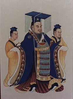
Emperor He Of Han & Empress Liang at the Royal Court. Source
The clearest account, however, comes from the reign of Emperor He of Han (88–106 AD). During this period, the Chinese envoy Gan Ying reported the existence of a kingdom named Doule (兜勒), which many scholars have identified with Adulis81, noting the linguistic similarity between "Doule" and "Adulis." This record is found in the Book of the Later Han (Eastern Han period, following the fall of the Xin dynasty).
Rough English Translation: “In the ninth year, Ban Chao dispatched his aide Gan Ying, who journeyed as far as the Western Sea and then returned. This was farther than anyone in previous generations had reached, and even the Classic of Mountains and Seas had not recorded it in detail; yet all of the local customs, lands, and rare wonders were thoroughly documented. Thereupon, distant kingdoms such as Mengqi (蒙奇) and Doule (兜勒) came to submit, sending envoys with tribute.” - Book of Later Han Volume 88 後漢書, section 3.
Conclusion
The port-city of Adulis, in its earliest days, engaged in trade with regions such as Punt and Southern Arabia during pre-antiquity. It would later witness the rise of the Ptolemaic dynasty, providing war elephants that helped the dynasty secure victories across the known world. This ushered in a surge of merchant activity which Adulis capitalised on, eventually leading to the rule of King Zoskales around the 1st century AD. Zoskales governed a vast territory along the Erythraean Sea, encompassing areas of modern-day Sudan, Eritrea, Ethiopia, and Djibouti. Through the hunting of elephants, rhinoceroses, and turtles, Adulis produced goods that were highly sought after from Egypt and Greece to Arabia, Persia, India, and even China.
Yet, this was only the beginning. Later in the 1st century AD, an unknown ruler emerged who would conquer vast territories on both sides of the Erythraean Sea, establishing one of antiquity’s greatest Red Sea empires. His conquests were immortalised on the Adulis throne inscription. Soon after, another seismic shift occurred with the rise of the Aksumite kingdom further south at Aksum, which in the following centuries would become one of the most powerful empires of its time. But what did this mean for Adulis? This will be explored in Part 2: Trade, Emissaries and War.
Nevertheless, this early period of Adulis' history played a pivotal role in shaping both the local coastal communities and the broader region as a whole. The goods produced and traded, along with the interactions with various cultures, influenced the fashion, customs, music, religion, and daily life of the region's diverse ethnic groups. Nearly a millennium later, the kingdom of Medri Bahri would rise in the highlands north of the Mereb - a name harkening back to the Erythraean Sea, and nearly 900 years after that, the colony of Eritrea would emerge — its very name borrowed from the Erythraean Sea, once sailed by Adulite merchants.
The provenance of obsidian artefacts from the Middle Kingdom harbour of Mersa-Wadi Gawasis, Egypt, and its implications for Red Sea trade routes in the 2nd millennium BC (Lucarini et al 2020).
Elephant Size in Antiquity: DNA Evidence and the Battle of Raphia, pg 63 & https://archaeology.org/issues/may-june-2014/digs-discoveries/raphia-battle-war-elephants-polybius/


")


