
Geo-trekking in Ethiopia's Tropical Mountains: The Dogu'a Tembien District — illustration 2, PDF page 76
Source record
- Source
- Habesha History book corpus — Geo-trekking in Ethiopia's Tropical Mountains: The Dogu'a Tembien District
- Book
- Geo-trekking in Ethiopia's Tropical Mountains: The Dogu'a Tembien District
- Source reference
- Geo-trekking in Ethiopia's Tropical Mountains: The Dogu'a Tembien District; PDF page 76; embedded illustration 2, exact source rectangle 56.69, 62.36, 362.93, 226.83
- Page
- 76
- Publication year
- 2019
- Type
- Book illustration
Date of image not recorded.
Creator not recorded.
Source-book and PDF-page attribution only. No place, subject, creator or image date is inferred from nearby body text or the publication date.
Source-page captions
Fig. 3.2 Ombrothermic diagram for Hagere Selam (2625 m). Notice the change in the y-axis scale above 100 mm (emphasized with different fill pattern). Mean annual precipitation 778 mm; mean temperature 13.3 °C; a mean monthly temperature; b months where P < 2T. Precipitation (Photo 3.2) and temperature data from National Meteorological Agency (NMA) (1973–1982 and 1996–2000)
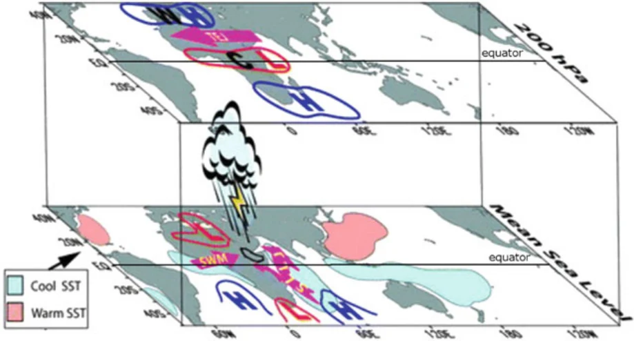
Fig. 3.1 Schematic diagram showing large-scale atmospheric factors and sea surface temperatures (SST) influencing June–September rainfall in Ethiopia. SWM SouthWest Monsoon and SLLJ Somali Low-Level Jet at sea level and TEJ Tropical Easterly Jet high in the atmosphere at 200 hPa (Zewdu et al. 2009)
Illustration from the identified source publication. Captions on the source page are preserved separately and are not asserted to belong to this individual crop. Publication year is not the image date.
Image rights
Original publication and credited image creators retain their rights. No open licence has been established for this corpus copy.
User-confirmed permission to use images in the local Habesha History corpus, 2026-09-28; this does not grant visitors a general reuse licence.
Request image removal