
Geo-trekking in Ethiopia's Tropical Mountains: The Dogu'a Tembien District — illustration 1, PDF page 178
Source record
- Source
- Habesha History book corpus — Geo-trekking in Ethiopia's Tropical Mountains: The Dogu'a Tembien District
- Book
- Geo-trekking in Ethiopia's Tropical Mountains: The Dogu'a Tembien District
- Source reference
- Geo-trekking in Ethiopia's Tropical Mountains: The Dogu'a Tembien District; PDF page 178; embedded illustration 1, exact source rectangle 56.47, 62.36, 363.49, 267.08
- Page
- 178
- Publication year
- 2019
- Type
- Book illustration
Date of image not recorded.
Creator not recorded.
Source-book and PDF-page attribution only. No place, subject, creator or image date is inferred from nearby body text or the publication date.
Source-page captions
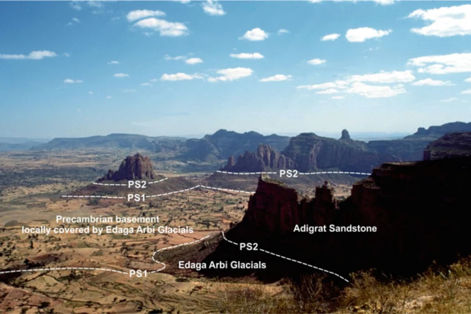
Photo 10.1 View from near the rock church of Mariam Korkor, close to Megab, looking towards the south-east (for location see Fig. 10.1). The plains on the left consist of Precambrian metamorphic and plutonic rocks that are unconformably overlain by a thin veneer of Edaga Arbi Glacials (separated by the PS1 planation surface). The Adigrat Sandstone forms steep cliffs above slopes of Edaga Arbi Glacials. The PS2 unconformity follows approxi- mately the break in slope. Similar views exist when looking down from the escarpment that forms the northern boundary of Dogu’a Tembien. Photo Robert Bussert (2003)
Illustration from the identified source publication. Captions on the source page are preserved separately and are not asserted to belong to this individual crop. Publication year is not the image date.
Image rights
Original publication and credited image creators retain their rights. No open licence has been established for this corpus copy.
User-confirmed permission to use images in the local Habesha History corpus, 2026-09-28; this does not grant visitors a general reuse licence.
Request image removal