
Geo-trekking in Ethiopia's Tropical Mountains: The Dogu'a Tembien District — illustration 2, PDF page 325
Source record
- Source
- Habesha History book corpus — Geo-trekking in Ethiopia's Tropical Mountains: The Dogu'a Tembien District
- Book
- Geo-trekking in Ethiopia's Tropical Mountains: The Dogu'a Tembien District
- Source reference
- Geo-trekking in Ethiopia's Tropical Mountains: The Dogu'a Tembien District; PDF page 325; embedded illustration 2, exact source rectangle 102.33, 330.8, 315.06, 481.61
- Page
- 325
- Publication year
- 2019
- Type
- Book illustration
Date of image not recorded.
Creator not recorded.
Source-book and PDF-page attribution only. No place, subject, creator or image date is inferred from nearby body text or the publication date.
Source-page captions
Photo 20.7 Dissected lobe of the Ab’aro debris flow (No. 36 on Fig. 20.1). At the top, the Tsili ridge (from where the debris mass originates). The blue arrow, in the centre of the photo, indicates the position of permanent springs (and tufa deposits) that evidence the build-up of a perched water table on top of the main limestone escarpment (just above the arrow). Current gullies highlight the edges of the landslide body. Many large rock fragments (including trachytes originating from the ridge top) can be found even much farther down in the valley. Photo Jan Nyssen (2017)
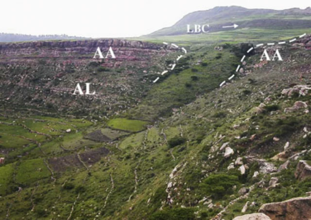
Photo 20.8 The May Ntebteb debris flow (No. 4 in Fig. 20.1). LBC: lower basalt cliff. AA–AL: Amba Aradam sandstone and Antalo limestone cliff. Weathering products of the lower basalt, mostly black swelling clays and basalt fragments, have accumulated in the landslide depositional zone, below the LBC. These debris accumulations surged over the AA. In the lower part of the picture, a gully obliquely crosses the debris flow lobe, which creeps down at a velocity of 3–6 cm per year. After Nyssen et al. (2006)
Illustration from the identified source publication. Captions on the source page are preserved separately and are not asserted to belong to this individual crop. Publication year is not the image date.
Image rights
Original publication and credited image creators retain their rights. No open licence has been established for this corpus copy.
User-confirmed permission to use images in the local Habesha History corpus, 2026-09-28; this does not grant visitors a general reuse licence.
Request image removal