
Geo-trekking in Ethiopia's Tropical Mountains: The Dogu'a Tembien District — illustration 2, PDF page 328
Source record
- Source
- Habesha History book corpus — Geo-trekking in Ethiopia's Tropical Mountains: The Dogu'a Tembien District
- Book
- Geo-trekking in Ethiopia's Tropical Mountains: The Dogu'a Tembien District
- Source reference
- Geo-trekking in Ethiopia's Tropical Mountains: The Dogu'a Tembien District; PDF page 328; embedded illustration 2, exact source rectangle 102.05, 363.86, 314.77, 476.62
- Page
- 328
- Publication year
- 2019
- Type
- Book illustration
Date of image not recorded.
Creator not recorded.
Source-book and PDF-page attribution only. No place, subject, creator or image date is inferred from nearby body text or the publication date.
Source-page captions
Fig. 20.4 Soil profile section (13 m long) within Vertisol polygons at Inda Maryam. Red dots: 138 chert rock fragments RF); dashed lines: transitions between soil horizons AB, B, BC and the silicified lacustrine deposits (E); rectilinear or slightly curved structures: slickensides; subvertical irregular line patterns starting from the soil surface: desiccation cracks; I, II and III: polygonal cracks at the soil surface. Between 11 and 13 m, the cross-section coincides with the limit between two soil polygons. Insets 1 and 2: detailed views of soil profile. After Moeyersons et al. (2006)
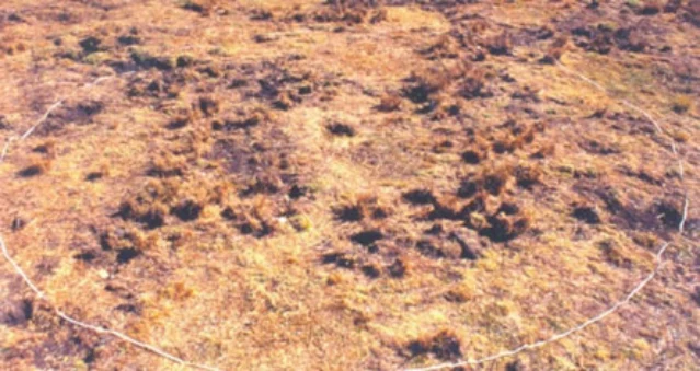
Photo 20.10 The circular experimental plot at Inda Maryam. The rope shows the border of plot, 10 m in diameter and having an area of 78.5 m2. The polygonal pattern of grass tussocks, growing along major cracks in the centre of the plot, is obvious. After Moeyersons et al. (2006)
Illustration from the identified source publication. Captions on the source page are preserved separately and are not asserted to belong to this individual crop. Publication year is not the image date.
Image rights
Original publication and credited image creators retain their rights. No open licence has been established for this corpus copy.
User-confirmed permission to use images in the local Habesha History corpus, 2026-09-28; this does not grant visitors a general reuse licence.
Request image removal