
Geo-trekking in Ethiopia's Tropical Mountains: The Dogu'a Tembien District — illustration 1, PDF page 471
Source record
- Source
- Habesha History book corpus — Geo-trekking in Ethiopia's Tropical Mountains: The Dogu'a Tembien District
- Book
- Geo-trekking in Ethiopia's Tropical Mountains: The Dogu'a Tembien District
- Source reference
- Geo-trekking in Ethiopia's Tropical Mountains: The Dogu'a Tembien District; PDF page 471; embedded illustration 1, exact source rectangle 104.88, 62.36, 317.4, 232.89
- Page
- 471
- Publication year
- 2019
- Type
- Book illustration
Date of image not recorded.
Creator not recorded.
Source-book and PDF-page attribution only. No place, subject, creator or image date is inferred from nearby body text or the publication date.
Source-page captions
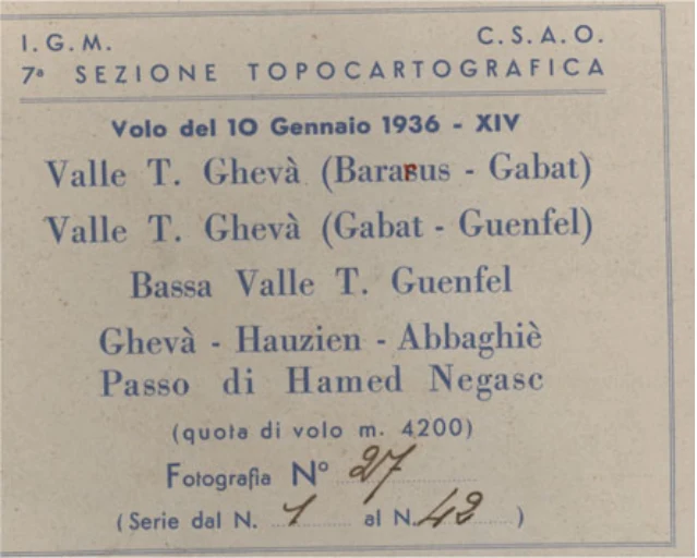
Fig. 31.5 Label corresponding to the aerial photograph represented in Fig. 31.4a (© EMA). The text indicates that the imagery was taken by IGM and CSAO (Comando Superiore dell’Africa Orientale), 7th topocartographic section. Flight date was 10 January 1936, in the 14th year of the fascist calendar (after Mussolini came to power). Approximate flight height was 4200 m. Photograph No. 27 in a series that goes from 1 to 42. Localities overflown were: Giba R. valley (Bararus–Gabat), lower Genfel R. valley, Hawzen, [Addi] Abbagiè (surroundings of Senqat’a) and Negash pass and Muslim sanctuary. Similar to this, most AP labels do not display straightforward indications of the flight line what complicates relocation
Illustration from the identified source publication. Captions on the source page are preserved separately and are not asserted to belong to this individual crop. Publication year is not the image date. Review note: 1936 aerial photograph archival label facsimile with original flight/provenance details; retain.
Image rights
Original publication and credited image creators retain their rights. No open licence has been established for this corpus copy.
User-confirmed permission to use images in the local Habesha History corpus, 2026-09-28; this does not grant visitors a general reuse licence.
Request image removal